Diorama

Diary
October 23, 2015

Refresh

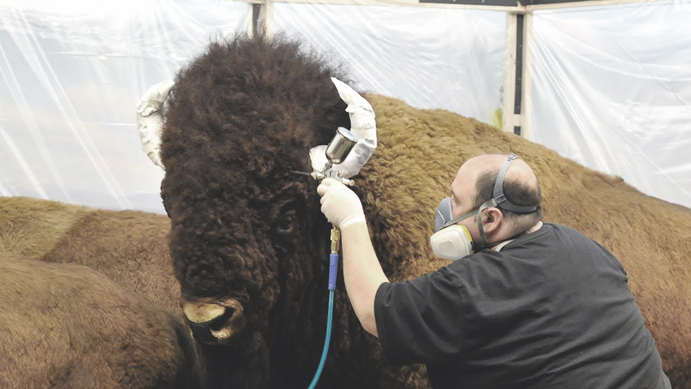
In 2014, the American Museum of Natural History restored the dioramas of the Hall of North American Mammals. Museum conservationist broke the seals and removed the single glass pane that enclosed the space allowing them to access the preserved landscapes. They fluffed and airbrushed fur coats, updated lighting, reapplied graphite to artificial shadows and revived and replaced seventy five year old vegetation that had crisped under artificial light. It was an aesthetic reset to a scientific medium.

When they broke the seals they must have asked themselves if the places which they represented had also changed. Did the pane of glass, oak mullion, and brass screw, preserve the landscape of the Sage Creek Basin in South Central Wyoming, the site of the Bison Pronghorn Diorama, as if magically encapsulating it in the same vitrine as its twin in New York: pristine, unchanged, just slightly faded? The restoration was an aesthetic reset of a scientific medium. The same airbrush that refreshed the 1938 diorama landscape in New York, had not reconsidered the contemporary landscape in Wyoming. A true refresh of the diorama would have allowed time to play out, refreshing 1938 to 2017.


The following is how I found a point of view.


[Figure 1001: Bison Pronghorn Diorama View]

Fig. 2: Staff member of the American Museum of Natural History airbrushing the coat of a bison speciman in the Bison Pronghorn Diorama.

The Bison Pronghorn Diorama is a sixteen foot hemisphere cut by a thirty two foot chord. The slice gives museum goers a view into 312,000 acres that the diorama was designed to represent. A space no larger than a walk-in-closet held an entire landscape, five bison and a coterie of prairie dogs. My apartment was smaller.


In one direction I could reach wall to wall, the other was slightly more generous into which I crammed the entirety of my life. I had left Columbia the year before and in an attempt to establish myself I corralled friends into working on architectural competitions where we would lay drawings across bedspreads. The intermezzo to our day jobs our beds held the plans for our futures, the bedroom was where we built our startups. But even in the spirit of our found conference rooms my space was too confined. So after team meetings, I retreated home where I continued working at a desk that barely left enough room to open the refrigerator behind it.


I wasn’t alone. Merica worked beside me. After dinner we cleared the hot plate that my uncle had given me to make room for our laptops.we had met at work, the only place I would find someone who understood why I worked as much as I did. At the sacrifice of the rest of our lives, we found in each other a need to create and in the meantime missed each other. We drained the ideas out of the 72 square feet I lived in. The space left no room for entertainment or relaxation. All the while, I fell in love with her in that space. I should have jumped at her first recommendation that we move in together, but I didn’t. Instead, when she was looking for her own place and was struggling to find anything usable, she asked if she could move in with me temporarily.


I thought that the confined size of my apartment spoke for itself.


When Hurricane Sandy knocked out power to Merica’s apartment we shared a week in intimate toleration of one another, but after two days of brushing by each other between that desk and refrigerator we needed to escape. We stepped out the front door where the debris from the storm littered my neighborhood. Splinters of glass that would never be replaced covered the stoop. A large sycamore tree arched its back over a wrought iron fence that surrounded Theodore Roosevelt Park. It lay waiting for a chalk line and if it had any elegance in the afterlife it would end up in the archives of the neighboring American Museum of Natural History, the building it had shaded. From the 1880s to the 1930s the museum was mandated to accept any specimen that the public offered.


Amateur naturalists who sought a dialogue with the natural world filled the museum with dead birds, small mammals and insects found in their backyards. In a moment of self sacrifice this tree attempted to give itself, unfortunately it didn’t know the museum had ended that policy eighty years before. The park that the tree belonged to was named after one of the museum’s most fervent donors, Theodore Roosevelt. As a child he culled, stuffed and cataloged specimen he found at his parents summer home on Long Island and deposited them into the museum. As a president he created nature preserves and passed conservation measures in tandem with the museum. At the end of his life he lived as an explorer, stocking the museum with thousands of specimen collected on expeditions to South America and Africa. As we walked through his park we paid our respects to the fallen tree and entered the museum that Teddy had contributed so much life and death to.


We went to the museum often, spending twenty or thirty minutes there at a time. Going to the museum brought me out of it. Its exhibits simulated nature and expressed as much about the natural world as the audacity of people who were compelled to recreate it. We were drawn to an honesty in the starkness of the New York State Hall. We walked through exhibits on the glaciation of New York, which described kettle holes, kames and moraines that punctuated and composed the terrain of our state.


Further in, the hall covered the evolution of cultivation from understory burning to contour plowing through cross-sections of the earth illustrating the root structure and gradation of soil that supported the vegetation above. The content was unassuming, it would have been just as comfortable in a local grange as an internationally recognized institution and we were taken by a matter of factness that required no assumptions of the viewer.


It was okay to be dumb here. The primary colors and straightforward graphics communicated this in the smartest way. Equally unassuming was the gem room, where all surfaces: floor, ceiling and walls, were lined in brown carpet. The room was a near match for the the interior of Jane Fonda’s ship in the 1968 erotic space-odyssey Barbarella.


In an attempt to project the future of sexual politics, Barbarella’s ship was draped in a continuous carpeted surface that flowed across wall, floor, ceiling and ottoman. It’s end purpose was an unfortunate embrace of the nude Fonda after a zero-gravity striptease in the title sequence. The carpet layering the walls of the American Museum of Natural History was more of a berber and less of a shag. What it lost in cinematic sensuality it gained in educational suggestion, here it represented the subterranean depths that held the monoclinic crystalline system.


Exhibits like the gem room and the New York State Hall were under-produced giving us the intellectual space for our minds to wander. In contrast, the museum’s contemporary exhibits suffocated our creativity. They were overtly educational and as we walked through the spatial equivalent of a fifth grade textbook the exhibition design loudly whispered in our ears. While the older exhibits left much unsaid, this was their success. In their silence they were able to communicate the obsessive passion of the people who created them and we found ourselves compelled to go out and explore the natural world.


The first was a backpacking trip to hike Devil’s Path, a long distance hiking trail in the Catskills named by Dutch settlers in the 1600s who believed the devil took residence in the notch between Plateau and Hunter Mountains. We traversed the ridge line with a group of five or six friends for two nights covering fifteen miles. I quickly would find that the severity of the trail would accelerate my introduction to hiking.


The Catskills are modestly short, they don’t break a treeline and the only views are where granite outcroppings have split the fabric of the forest. To make up for a lack of height, they cut through boulder scrambles and between cleaved notches. We made camp in the notches and hollows where each of us was responsible for preparing a meal for the rest of the group. I had packed pizzas. The week before at work, as files loaded, I Googled backpacking food.


People who grow up camping have a comfort level with the outdoors, it’s the people like me who are new to the sport that step outside for the first time as an adult. I had befriended anxiety at work and now I brought it into the wilderness where every fear was paired with its own breed of over preparation. With the food, I brought a Bushwick pizza place with me, all the ingredients for the pizza with each serving well chopped in little plastic baggies for six people. I counted out each sheet of foil we needed and every tablespoon of oil.


The wilderness I knew up until that time were the domestic wetlands, farmlands and woodlands that surrounded my childhood in Ohio. Commonlands are dastardly missing in the Midwest, ninety five percent of the land in Ohio is under private ownership. Merica’s childhood made up for my lack of wilderness experience. She was raised in the public land rich state of Utah.


She and her father backpacked through the Unitas carrying bottles of wine into the high country so that he could show her where he wished to have his ashes buried. He also was one of the first people to recreationally float the Snake River. He bought up military surplus rubber rafts and on any errant weekend he and his friends would casually drop in. Merica’s mom came to Utah from Chicago for the dry snow of the Wasatch Range and before Merica could walk she and her brother were strapped to her parent’s ski suits. Hiking and camping were absent from my childhood but defined hers, willing or not, she was my guide to America’s public land system.


[Figure 1003: Map - Ohio vs Utah Federally Owned Lands] [Figure 1004, Spread: Devil’s Path Montage]


She gave me the West.


Our first trip west was to Glacier National Park in Northern Montana. After driving eleven hours from her parent’s house in Salt Lake City we arrived at the Logan Pass parking lot. As we pulled into our parking spot the view framed in our windshield was replicated two thousand miles away in a diorama in the Hall of North American Forests at the American Museum of Natural History. The diorama was conceived of as a way to bring the land to remote viewers in urban areas.


Based on the cyclorama and curio cabinets of the 19th century, the diorama forms a hemispheric room which the viewer stands at the edge of. Along its curved back wall is a landscape background painting, one of which depicted the alpine perch we arrived at in Montana, overlooking the Going to the Sun Road and High Line trail. The work was the last by the noted background painter Francis Lee Jacques. When it was completed it was shown to the benefactor of the window who was unhappy with the sober reality of Jacque’s portrayal and requested for the scene to be repainted with a foreground of flowery foliage. His ego wounded, Jacques was unwilling to repaint the background painting himself and a novice was brought in to make the changes. In his absence, the inexperienced artist flattened the scene’s depth of light. Jacques’ dissatisfaction with the revision fomented into protest and he never entered the museum again.


From the start, Jacque’s original was at a disadvantage. It’s station point was an embarrassingly unremote asphalt tarmac of the Logan Pass visitor center. Back in Montana, Merica and l stepped out of our car and through the frame of Jacques last work onto the Highline trail, an eleven mile route that traced the shoulder of the Continental Divide.


Two hours in and yet to turn around we were counting the hours to sunset, we scrambled to 10,000 feet to an overlook of Grinnell Glacier, a glacier we renamed Horace, or Harry, or whatever. He was one of twenty five glaciers that still existed in the park, all originating in the last 6,000 to 8,000 years. Looking down onto the glacier, the air parted on the edge of a thinly cut ridge that fell away to a glacial cirque that fell further into a vein of glaciated valley. It was a long view that elongated further into my memory.


Behind us was a frontal view of the rest of the park. The mountains of the Lewis Thrust held themselves with composure, telling themselves to be handsome: proper in posture, shoulders back and chin up. The wind leapt over us from one side of the park to the other.


This edge of two worlds was the view the parking lot diorama should have captured and released in New York. We would have done it ourselves but we weren’t aware of the coincidence until we returned to the museum and found ourselves standing in front of our own memory. Below a supply air vent, we felt the wild wind of the Lewis Thrust escape through the hewn wood that framed Jacque’s work. Dejavu greeted us. It was a fitful double take of two places in one, an introduction to the power of the diorama.


[Figure 1005, The View Jacques should have caught] [Figure 1006, Constructing Glacier Diorama] [Figure 1007, Mike and Merica in front of Glacier Diorama]


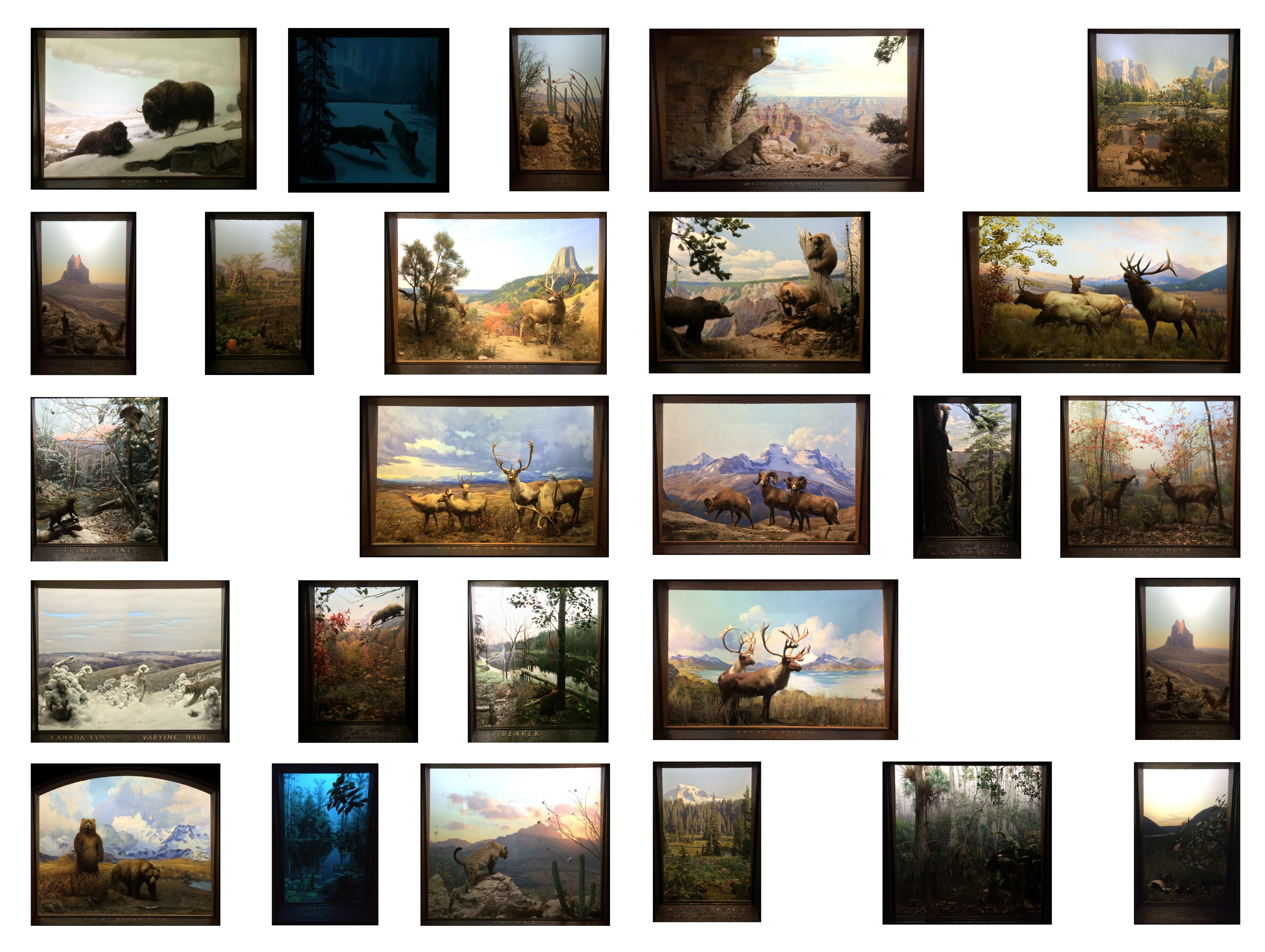
The dioramas in the Hall of North American Mammals were created in the 1930s and were conceived as a scientific tool for extending field research into the museum where a broader and more urban audience could access the remote places which they represented. They were an unnatural duplication of actual places creating a portal from the natural history museum to points throughout the North American continent.


The closest is the whitetail deer depicted at Island Pond a forty five minute drive from the museum in Harriman State Park. The most remote, the musk ox grouping is so isolated that the curators never actually sent a background artist to the site in Nunavut, Canada. Between these two are a range of forty-six North American mammals that form about one tenth of the biological range that exists on the continent. The resolution of the duplication of the mammalian habitats required every detail to be recorded and replicated in highest definition. The museum collected plant specimen, color matched landscapes, and articulated taxidermy armatures to create an artistic xerox of natural environments that they feared were vanishing.


Fig. 2: Dioramas of the North American Hall, AMNH. From Top Left: Musk Ox, Grey Wolf, Jack Rabbit, Cougar, Coyote, Spotted Skunk, Cotton Tail Rabbit, Mule Deer, Brown Bear, Elk, Fisher, Caribou, Big Horn Sheep, Squirrel, White Tail Deer, Bobcat, Oppossum, Beaver, Carbiou, Bison, Grizzley Bear, .

[Figure 1009: Diorama Floor plan]


Dioramas continued a tradition of collecting and cataloging that was central to science one hundred years before. The early 1800s were the beginning of the end of global exploration, the terrestrial world was on the verge of being known. It would be less than one hundred years before the advent of world cruises would allow the average citizen to leisurely circumnavigate the world. Seafaring explorers had fewer virgin territories to claim and their attention shifted to the documentation of already known landscapes. They were in search of mineral veins, scientific insights, arable lands and safe harbors that were missed on cursory passes.


Holding onto enlightenment era attitudes, they saw the exploration of the world as an exploration of human knowledge. It was a task not capable of being bound in the contours of a career so to makeup for this they redefined themselves as a type of polymath, an artist, adventurer, explorer, scientist. Bit by bit they captured the world and sent it back to central processors back home. They were the cursor of the nation and the natural history museum was the data center, a collection of the natural world where the specimen formed a sort of hypertext that linked disparate parts of the world together.


At the time, the underlying structure of this global web was Linnaean classification which grouped plant and animal life into strict taxonomic families which allowed explorers and scientist to easily sort through the content when they returned home. By the time Darwin was on his boat in the 1820s the field of natural history had begun to splinter into discrete sciences. Natural history became biology, zoology, and botany which would split into narrowers concentrations such as herpetology, comparative anatomy, geobiology and on. This process was a shift away from the singular act of collecting and categorization that was the root of Linnaean classification towards an attitude of experimentalism which asked how those categories participated in a dynamic and ever evolving world.


It would take one hundred years for the Natural History museum to sync with the shift. In the 1920s and 1930s the museum as a typology was undergoing a radical transformation from an insular academic warehouse to an extroverted institution with a mandate to educate the public. The diorama was the final punctuation mark in this baton pass. Underlying this transformation was a reform movement that championed the educational role of the natural history museum called the New Museum Movement. It advocated for science to no longer be held opaquely within the institutional boundaries of a university and sought to democratize the scientific process.


Museum Men, the protagonists of this shift, were a group of Progressive Era curators and exhibition planners who believed that shared intelligence led to an egalitarian society. Artistic expression was no longer forbidden and exhibition design was now multivalent and inclusive rather isolated and controlled. Natural history museums moved away from the strict taxonomic classifications and experimented with new organizational systems that described the interdependencies between species.


Catching the trajectory of modern science, the diorama was the physical manifestation of this shift. It was an open source medium, curators traded techniques amongst institutions. At one museum a curator experimented lifelike posturing, another added a pictorial background, the next added site sampled vegetation, it was through this cumulative process that the contemporary diorama was generated. As the diorama matured the scientific intent became clearer, the content around a specimen was as important as the specimen themselves. Museum men planned elaborate expeditions to collect the animal as well as its habitat, plants, soil and panorama. These expeditions closely resembled the old style of Natural History by reviving curators as a type of polymath that was equal parts explorer, artist, hunter and scientist. It was the type of adventure that Alexander Von Humboldt or Charles Darwin embodied.


Darwin hated the boat that made him famous. He had violent bouts of seasickness that left him favoring the land over the sea. He would spend five years on the boat and never fully reconcile his nausea. It followed him from England to South America, around Cape Horn, through Tierra Del Fuego, on the way to Australia, as he rounded the Kneel Islands and as he wrapped the tip of Africa at the Cape of Good Hope. His vessel, The Beagle, was at the command of the British Admiralty with instruction to complete existing maps of the coast of South America and raise the flag near British holdings to remind them that the Crown had not forgotten them. The Beagle was mandated to create an inventory of potential sites for natural resource extraction by documenting the geology and botany of the continent.


Darwin saw this as an opportunity to establish his career as a biologist, as did the majority of the educated crew. The whole damn boat saw themselves as naturalists. It was a common expectation on voyages like this for the surgeon to not abuse his intellect. While the crew was healthy it was assumed he would note the natural environment. For Darwin, the journey’s purpose was a matter of professional practicality. It was a trip where he could establish his credibility through experiencing the natural world, a five year long in-the-field internship. At twenty-two Darwin, was only four years younger than his captain Robert Fitzroy. A combination of their innocence and their shared interest in the natural environment led to a mutual affinity for one another. In addition to a berth on the ship, Fitzroy allowed Darwin to take extended leaves to travel overland. On shore Darwin escaped his nausea and it was where his most consequential observations took place.


In October 1835, four years into the voyage, Darwin describes the perfect gradation in the beak of a series of finches that he found on the Galapagos. He understood that their confinement on separate islands contributed to the mutation but he didn’t full realize his discovery in the moment. His epiphany was truncated by the pace of his travels and he wouldn’t fully expand on it until he disembarked from the Beagle in England in 1836. It was through conversations about his travels years after the fact that elicited a theory from Darwin. He would have missed the epiphany if his colleagues hadn’t recognized the importance of what he had experience as a passing curiosity up unto that time.


Darwin’s dispatches were not a thesis but a continuous feed of thoughts, experiences and feelings. A record of his daily life. Thoughts on evolution and transmutation are only intermittently interjected amongst his personal experiences. They make up a small portion of the five years on the Beagle and an even smaller portion of the actual text of his journals.


His journey writes itself in anecdotes. Somewhere in Argentina, he attempts to learn how to rope a steer with a pair of bolas which are weighted lead or cast iron balls attached to each other by leather straps. When thrown, the steel and leather wrap around the legs of the animal incapacitating it.The Gauchos who taught him watched as he swung the balls over his head. He released them clumsily and roped the legs of his own horse incapacitating himself in front of the frontiersmen who he fondly respected. His humiliation is the subject of his own observation.


These personal moments are the cartilage between scientific inquiries. By viewing the full experience of Darwin its clear his journey was both inward and outward, a way to find himself while finding the world. Confined to a boat, his life and vocation were inseparable for the five years that he travelled. It was the type of vocation that required a diary, a lifestyle he model after Alexander Von Humboldt whose “Personal Narrative of a Journey to the Equinoctial Regions of the New Continent” defined the template for scientific self-exploration which inspired Darwin to explore the Andes and Galapagos.


In March of 1835 as Darwin crossed the Cordillera of the Andes he gave a literary sketch of the geological structure of the mountains. He describes the dull red and purple claystone porphyry and hard igneous rock sparkled with crystals. He shifts from the microscopic scale of the granular makeup of the rock in front of him to descriptions of the penetration, upheaval and overturn of continental plates. At 14,000 feet Darwin thinks of Alexander Von Humboldt who ascended the same range in 1805.


Von Humboldt was the world’s foremost mountain climber and had ascended the dormant volcano Chimborazo to 19,000 feet, just 1,500 feet short of the summit of what at the time was considered to be the tallest mountain in the world.


On a stretch of logic Chimborazo still is. Earth’s ovoid shape and Chimborazo’s proximity to the equator positions it’s summit as the piece of earth closest to outer space and the furthest from the earth’s core.


While Von Humboldt didn’t summit Chimborazo, he did notice a gradual shift in vegetation that corresponded with his rise in altitude. In a single drawing called the Naturgemalde, he communicated a complex relationship between climate, habitat and geography. It is a cross-section of the mountain with species labelled at the elevation where they occur along the transect of the mountain. He started in the forested foothills, climbed above the treeline, and continued into alpine habitat. Each strata of the mountain was a unique ecosystem that unto itself could be thought to be independent. When considered within the scope of the entire mountain they acted in unison as an interdependent system. No one before him had conceptualized nature in such a vast and encompassing way. (Wulf 88) Both, the concept and the medium he used to communicate it were revolutionary in their immediacy.


When Von Humboldt returned to Europe he compared his notes with the only person who had been higher than him. Joseph Louis Gay-Lussac, a French physicist, ascended to 23,000 feet in a hot air balloon to measure the effect of altitude on the composition of the atmosphere and electromagnetic field of the Earth. Von Humboldt and Gay-Lussac compared their measurements at altitude and quickly created a personal relationship travelling and lecturing together. Their bond was formed around a vantage point near the top of the troposphere. From this view, Von Humboldt saw the interdependencies that made up the natural world. He saw the world as a fluid geography that tied all living beings together and relinquished the narrow silos of Linnaean taxonomic classification that up until that time structured scientific thought. In its place he created a new system of classification that characterized species by their interdependence rather than isolating traits.


Point of view is Von Humboldt’s most effective tactic. Von Humboldt's was wide angle and suspended in the air. It was through this pre-sputnik, pre-google earth, bird’s eye view that he could expression his unifying vision of the world. Point-of-view was also his method of dispersion, it was through imagery and personal narration that he disseminated his thoughts. The strict outline of Chimborazo held weeks of his records. It was only through the collection of his personal experience, months of travel, layered on months of travel that he could articulate a thought that was so out of human proportion. It required that his body move through his subject at the length of an expedition.


The magnitude of Von Humboldt’s influence litters our geography from Humboldt County, to Humboldt Peak in Colorado, to Humboldt Range in Nevada, to Humboldt Range in Antarctica, to Humboldt Range in New Zealand, to the Humboldt current that the H.M.S. Beagle drifted through along the western coast of Chile, to Humboldt glacier in Greenland his name is as interwoven into our geographical nomenclature as were his ideas. His popular success was found not just in the breadth of his ideas but in his ability to communicate them in a way that spoke to the humanity of a popular audience. He invented the term Cosmos to apply his theories of interconnectedness to the entire universe.


He would spend the remainder of his life trying to synthesize the capacity of human thought to describe the totality of all that was known. Von Humboldt’s reach was lofty, and while he was attempting to describe everything that existed he brought it to a sharp point through his own experience. It was through the deliberate illustration of a point of view, whether his own in “Personal Narrative” or of one he fabricated in the form a two dimensional diagram of a mountain transect, point-of-view was the medium through which he described the Romanticism of science that he learnt at an early age through his conservations with Goethe. To Goethe and Von Humboldt science and art were inseparable, they considered both equal part in describing the human condition. The conflation of the two was the point-of-view that the Museum Men revived nearly a century later in the format of the diorama.


James Perry Wilson wrote to the diorama artist Thanos Johnson in August 29, 1944 describing the thirteen graduated tints he uses to cover the range of values in a sky. Three or four dabs of white, a tint of ruby madder, a tint of cadmium lemon and one or two tints of of blue. He continues to describe the effects of atmosphere on the coloration of clouds as they recede into the distance: clouds nearest will be flush white, clouds halfway between you and the horizon will have a yellowish cast as the atmosphere filters out that wavelength. As the clouds approach the horizon an even thicker atmosphere will filter out the reds as well. The color of the atmosphere was also an obsession for Von Humboldt in his journeys along the Orinoco. He brought with him a cyanometer to measure the blueness of the sky which he record as he ascended Chimborazo. Like Von Humboldt, Perry conferred with a high altitude balloonist to further his understanding of the atmosphere’s effect on light. In an exchange with Captain Stevens, whose balloon the Explorer II rose to a height of 73,000 feet, he learned that the thinner the atmosphere the whiter and more intense sunlight was. Wilson’s artistic curiosity was hued with the rigor of an empiricist and his exacting nature was a natural companion to his shy personality. His observational advice to Thanos was not polemical, it was factual, an attempt to communicate the care one must take in reconciling subjective aesthetic principles with the objective physics of light. His observational power led him to become the preeminent diorama painter of his time.


[Figure 1010, Sky paint samples]


He was trained as an architect but it only delayed his true vocation: painting en plein aire. His route to his true passion was indirect. As a teenager, a neighborhood friend introduced him to landscape painting and he developed his technique painting en plein aire in coastal Monhegan, Maine and in the countryside of New Jersey. It was a practice that would stay in the background of his life occasionally appearing on vacations upstate where he made a habit of perfecting his skill in the semi-nude to nude. He redirected his life towards architecture when he enrolled in the newly created Columbia School of Architecture. After school, he found comfort working for the architect Bertram Goodhue, an architect who would spend a life searching for a style but would never find it. While Goodhue’s architectural influence never manifested, he was one of the preeminent architectural visualizers in the early 1910s and 1920s. Wilson’s skill for scientifically casting shadows was quickly recognized and he found a place in the office. He not only excelled professionally with Goodhue, he found a safe community that accepted him as a socially reserved gay man. Wilson thrived in this environment and would have most likely completed a career their if the firm’s founder had not died in the midst of the Great Depression. Wilson was laid off in 1932. This left him free to make his plein aire jaunts a vocation.


When Perry Wilson came to the American Museum of Natural History he entered a competitive culture that contrasted with his experience at Bertram Goodhue. He came into a world where he was an unusually slow painter and he was accused of stealing paint. He arrived during a period of expansion which was overseen by the newly appointed director James L. Clark. The weight of expanding the museum so soon after the depression was a elephantine task of courting donors, balancing powers among museum departments and reconciling the popularity of the diorama which brought in large audiences and ticket sales. The museum defaulted on its loans during the Great Depression, half of the institution’s endowment had been in railroad bonds, and it was the diorama that was responsible for recuperating losses through attracting lucrative donations. Because of its ability to attract donors, the importance of the diorama within the portfolio of the museum was outsized and the Hall of North American Mammals siphoned funds away from other departments that were badly in need. Clark had to extinguish skirmishes that ignited between departments competing for diorama money while also promoting the diorama because of its ability to draw large audiences. When Perry Wilson arrived at the museum the dioramas were at the height of their popularity and they were also the financial savior for an underfunded museum.


Clark came to trust Perry Wilson. The museum had already formalized the technique for executing a diorama when he had joined. Perry Wilson was indoctrinated in the process under William R. Leigh, a disciple of the father of the diorama, Carl Akeley. Akeley taught truth in nature and encouraged a strong distrust in the individuality. Wilson learned the techniques of site value studies, adding buttermilk to dull glossy paint and strategies for rendering atmospheric perspective and distance deception. Leigh, who had been trained in the German academic tradition wasn’t true to Akeley’s ethos and embellished landscape features and atmospheric lighting to add theatricality. Wilson’s scientific sobriety bleed the artistic ego out of Leigh’s process by adding a level of precision to the already perfected methods of the museum. He transcribed two dimensional scenes onto the curvature of diorama shell using a method he developed for projecting a grid onto complex curvature. The grid was adjusted to morph as it approached the viewer distorting the objects in the periphery of the image so they were perceived to be flat.


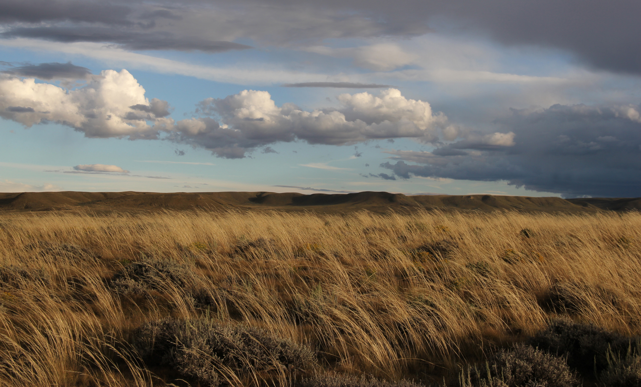
At 11:15 pm on September 3rd of 1938 Perry Wilson departed Grand Central Station for the American West. He was sent to find and capture a site for the Bison Pronghorn diorama grouping. He arrived in Billings where he purchased a 1938 Ford pickup and drove with foreground artist George Petersen, taxidermist Gardell Christiansen and mammalogist T. Donald Carter along the Red Lodge Highway through Yellowstone Park where they made their first stop to conduct studies for a Grizzly grouping. They continued on to Mammoth Hot Springs, through Cody and eventually arriving in Saratoga Wyoming on September 21st where they would spend a week. It was in the Sage Creek Basin in 1938 where they began the process of constructing the Bison Pronghorn Grouping. The dioramas consist of three main components, each represented a man on the expedition. A foreground collage of collected vegetation of blue grama grasses, buffalo grasses, sage grass, rock and soil samples were collected by George Petersen. Pronghorn antelope specimen were observed and culled by T. Donald Carter. James Perry Wilson captured photographic panoramas and plein aire compositional paintings to study the form and coloration of the landscape.


[Figure 1011, Perry Wilson on-site]


The bison were collected on an expedition the following winter when the animal’s coat was the fullest. The animals were harvested under permission from the United States Biological Survey from the National Bison Range in central Montana established by the American Bison Society in 1904. A “large bull, a medium-sized bull, a large cow, a young cow, a two-year-old spike horn, and a small eight-month old calf” were harvested from a herd of 640. Bison were so few that it was unlikely that they existed in South Central Wyoming at the time Perry Wilson visited. While most dioramas were precise replicas of landscapes as they existed, the Bison Pronghorn Grouping was an exception, it purposefully recalled bison and pronghorn populations of the 1820s to educate the public of their near eradication and revival through ongoing conservation efforts.


The Bison Pronghorn Diorama is situated in the most prominent position in the center of the Hall of North American Mammals. The group consists of five bison grazing in the foreground of sagebrush plains, skittishly close to them is a grouping of pronghorn. Clark was entrusting the untested Wilson with the success of the Bison Pronghorn diorama, one of the largest executed, and in turn the success of the entire hall. The collecting trip in 1938 was Wilson’s first and while it is comparatively short compared to the multi-year expeditions of 18th and 19th century, like Darwin or Von Humboldt it was a continuation of his personal narrative. It was nothing more than the vacations he took to Mohegan or New Jersey to paint en plein aire, he stood semi-nude on the foothills of the Sierra Madres shirtless mixing colors and matching hues. The diorama was a superimposition of himself onto the Sage Creek Basin. In the same way Darwin needed to retrace Von Humboldt to come to his theory on evolution and Von Humboldt needed the Orinoco to come to his Personal Narrative the act of embarking opened Wilson to an intellectual landscape not available in New York. Only by being there could he be the antenna of that place, tuning himself into the site. He obsessed with the reality of the site, every piece of terrain was placed with precision, you feel the dew point, the atmospheric pressure, the wind speed and the uv index, what you mostly feel is yourself just as Perry Wilson had.


Perry Wilson resisted the theatrical drama of the German School of landscape painting that had been perfected by Albert Bierstadt. Bierstadt’s last painting hangs alone in a transitory hall of the National Gallery in Washington D.C. It was slightly smaller than the apartment Merica and I escaped from at 5’-11” by 9’11”. It depicts the destruction of the bison. A few feet into the image a triplet of bison lay prone, one clearly dead and two others contemplating death. Behind them is a bull bison in a mele with an indian mounted on a white horse drawn back on its hind legs. The horse prances among the bison bones that fill the foreground. Receding into the scene are scores of animals who are complicit in the violence as they witness the death that preceded their own. Bierstadt depicts death in the last light of the day. The landscape shares culpability in the crime as an enveloping basin shepherds the herd into its shadow where escape is unlikely. Unseen aggressors are presumed to be just over the ridgelines that frame the horizon. Removing the violence from Bierstadt’s “Destruction of the Bison” leaves an image close to what Perry Wilson found in the Sage Creek Basin. In an eire pantomime, Wilson’s background painting recalls Bierstadt’s raised foreground and swiftly sweeping basin.


The “Destruction of the Bison” was the definitive work of Bierstadt. Executed in 1888, it was created at the moment bison were in most peril, with numbers in the low 1000s. Bierstadt’s landscape was a fiction. It was a collection of topographical features that don’t exist together but are a sampling of his trips through the American West. The Bison Pronghorn Diorama was a tribute to this tribute. Bierstadt harkened the past image of mass herds of bison to evoke the weight of their loss and Perry Wilson cleaned up the violence to render it an aspirational tool for American conservation. Wilson filtered out Bierstadt's emotional weight and rendered the scene with his trademark precision. Bierstadt fabricated an idealized landscape immersive enough to hold the emotional complexity of the eradication of a species. Perry Wilson found the actual place and attempted to use it to save them. No fiction was needed.


[Figure 1012, Bierstadt: Destruction of the Bison]


Seventy seven years after Perry Wilson went to the Sage Creek Basin in a Ford Truck, I followed with a girlfriend, a rancher and his wife in a Ford Truck of our own. When Merica and I left my apartment that day to escape the Hurricane, one of the many places we found within the museum was the Bison Pronghorn Diorama. We stood gazing into the artificial landscape unaware that we would find the actual place, we were unaware of the forthcoming expiration of our relationship, and we were unaware of how drastically the Sage Creek Basin would change in the nearest future. My spirit was linked with Perry Wilson. Somehow through that frame he communicated the importance of a singular view back to me. The parallels in his life story with mine haunts me. He and I both trained as architects at Columbia. We both excelled as renderers in architectural offices in New York. We both craved an extracurricular life centered around nature in one of the most unnatural cities in America. His work drew Merica and I to Wyoming and in 2015 we would recreate his trip. The dioramas served as a benchmark for not only how the land has changed in the last seventy seven years but also how our attitude towards the land has changed. An attitude that is played out politically, economically, and culturally. In 1938 there was a need to preserve these places that they saw as so threatened that it was worth duplicating, relocating and sealing them in glass. The passage of time gave us a new window into these places: we could check in to see if they survived.


So we did


[Figure 1013, Photo, Truck Tire] [Figure 1014, Bison Grouping with Balloon]

Diorama Diary


Volume Two

November 25, 2015

Lay of The

Our 1500 mile approach to the diorama site was the frame around it. It’s edges followed the grid of the 1785 Land Ordinance, a landscape gradient that started in the deciduous suburbs of Chicago that divided into checks, townships, sections and quarter sections by the roads and county lines. It took us into the high altitude desert of the west. By the time we arrived in Southern Wyoming we learned the lay of the land was not geological. It had little to do with the grasses that grow there. The soil-composition really wasn’t that important, nor were the exact locations of the nesting sites of the greater sage grouse. While each grouse was a pin in a map, what was truly pinned was human ambition. We gained access to the landscape through the people who were shaped by it. By knowing them, we also knew the soil, grasses, and most importantly, wind. It was a landscape that was starkly human and an expedition that started out naturalistic quickly turned journalistic as we neared the site.

After crossing the cornfields of lower Wisconsin and the Badlands of South Dakota we stopped at a gas station off Route 130 on the edge of Saratoga, Wyoming. As we stepped through the dark aluminum framed door of the Conoco country store, we learned that there had been a fire at the lumber mill. We learned that the son of the lady at the register was okay. He had to run in late last night to help save the mill so he could work the next day. We learned his day was ending as we were beginning ours. We saw a rotating rack of maps. I pulled off a Bureau of Land Management map off a stainless steel rack that rotated drunkenly next to the cashier. The maps are published by the Bureau to distinguish public and private so as you are out on an ATV hunting pronghorn you don’t commit the faux pas of crossing into someone else’s land. In Saratoga the gas station is the grocery, fueling station and welcome center. While there is a ranger's station in Rawlins, it wasn’t worth driving another forty five minutes to get the BLM maps at list price. The local gas stations bought them to mark them up from four to eight dollars.


The Bureau of Land Management was created in 1946 to manage the nameless public lands of the American land-system. Escaping a clear definition of ownership, they were treated as an open commons throughout the first half of American history. Covering eleven states and comprised of 400 Million acres they are the largest allotment of federally owned land. With most their holdings in the West, BLM lands form a sagebrush shadow to the Rocky Mountains that stretches nearly to the Mississippi river. While, owned by the federal government, unlike a National Park, they lack a clear purpose. Arid and alkaline, they had originally been passed over by the first rounds of homesteading and unwanted their use was fractured. They initially weren’t beautiful enough to be preserved. They were too inaccessible and culturally invisible for recreation. They were productive, but maybe too much so, leaving them at risk of depletion. As a public landscape shared between the American people it was not exactly clear what we were sharing. Cattle, recreation, preservation, mineral extraction and energy development, were all competing for the same land.


It was ten years after the Grazing Service was created in 1936 that President Harry S. Truman merged the Grazing Service with the General Land Office to form the BLM in an attempt to streamline the management of public lands. Despite this attempt the early BLM lacked a clear vision for the American Public Land System and disaffected, ranchers claimed them as their own. Ambiguity of ownership exacerbated the differences between the BLM and its rancher clientele. The 400 million acres that the BLM was initially tasked with managing was an intermingled patchwork of federal, state and private lands with no clear edge between them. Ranchers leased land from the federal government at extremely subsidized rates and entangled them with privately owned tracts forming ad-hoc hybrids of public and private creating a not so public public commons. Often, access to public lands required right-of-way permits to cross through private lands and ranchers were not willing to grant them. When the government attempted to resolve the messy land-use patterns they threatened to let ranchers’ leases expire and shut down access to adjacent public properties. Ranchers felt their sovereignty was violated.


The conflict between the federal government and private landowners was stoked further in 1976, the American Bicentennial, when the federal government officially closed the frontier. Congress passed the Federal Land Policy and Management Act (FLPMA) formally ending the homesteading in the continental United States. It signaled to ranchers the end of their individual autonomy. The BLM administered a doctrine of rational surveying and land planning practices based in peer-reviewed scientific study which replaced the generational knowledge passed down by ranchers. Through an encompassing national view, the federal government sought a cohesive strategy to manage national land-use. It moved away from a decentralized system that responded to western user’s input and deployed a centralized planning system rooted in science and academia. This alienated western landowners and the FLPMA act led to revolt. In the late 1970s and early 1980s western landowners staged the Sagebrush Rebellion a political movement in which Western states and landowners resisted the government’s efforts to regulate public land. Western landowners pushed an agenda of federal land disposal and called for the federal government to release its land holdings to state, local and private ownership.


Forced to solidify its stance, the Sagebrush Rebellion was a point of maturation for the BLM. It was an agency that lived in two worlds, in the offices and the conference rooms in Washington and regional field offices and the other in the natural world. The split was emblematic of the virtual reality of governing and how inarticulate policy was in describing the natural world that it is attempting to regulate.


The idea that the rancher could be regulated was a paradox. The rancher was endemic within the sagebrush ecosystem and the BLM could have chosen to regulate the rancher as a species along side of the mule deer and elk but instead the BLM divorced the rancher from the land. The separation was an attempt to create a more inclusive definition of human habitation in the American West.


The FLPMA was only the apex of this process, the framework had been in place leading up to the rebellion. In the 1960s the BLM systematized the natural world through an inventory of the American Public. The inventory allowed the BLM to analyze and allocate lands for specific and diverse uses, without the inventory, the federal approach to land management was conducted scatter shot. They hoped that an honest portrait of land use would show a habitat that is capable of holding multiple user groups. Recreation and conservation were elevated to equal importance as production. The biologist, the thru-hiker and the birdwatchers were introduced as active specimen into the American wilds.


Land classification shaped a national vision for how public lands should be used and gave a sense of clarity to its constituents. The inventory and the FLPMA took American lands out of their adolescence and reigned them in for the production of the American public. For Merica and I, members of this public, the map that I picked off of the rack in the Conoco was deceptively simple, land was subdivided into the grid of the Land Ordinance of 1785 and then color coded by ownership. Yellow was federal land, light blue was state and unmarked was private land.


Startlingly, the map depicted Southern Wyoming as a checkerboard of ownership with one mile by one mile sections alternating between public and private. The entire map, not just a segment, was a quilt of land-use. Its strict grid was carefree of the topographic features that lay under and in it we felt the humanness of the map. I could not resolve the dissonance between the wide open spaces that we had just driven through and the constrained plots that the map delineated.


The checkerboard was a remnant of the Union Pacific's bid to build a transcontinental railroad as part of the Pacific Railways Acts of 1862 and 1864 which granted 174 million acres of public land for a railway and telegraph line that would connect coast to coast. The construction of the railway was steeped in controversy as congressmen colluded with financiers of the railway and received kickbacks on the approval of the line. The undertaking of constructing a transcontinental railroad was an effort of nation building at continental scale and it preyed on the ambiguity between public and private to muster the brute financial and political force needed to succeed. The land was granted in a 40 mile swath within which the Union Pacific could chose an ideal line and the remainder of the land was to be sold in order to fund the project. Unlike the arable East, no one bought the lands in the arid West. The deal agreed upon between the federal government and the Union Pacific was that fifty percent of the land granted to the railway would be returned on completion of the line. When it was returned every other section was given back. The Union Pacific checkerboard blurred a public land system that was already out of focus.


The land holds a lasting imprint of the human ambition that fueled the project in the form of a rigid geometric checkerboard. There are many ways to give back fifty percent of something and it remains questionable why it was given back piecemeal instead of discrete and purposeful chunks. Whether the inbreeding of public and private lands was purposefully sinister, it remains a fuck you to the American Public forever embroiling their land in a confusing cocktail of whose-is-whose that is equally unfair to people who wish to enjoy the beauty of the land as it is the people who wish to produce from it. It is an ambiguous land-use condition that could only be a result of human motivation.


Today, Wyoming has adopted the attitude of making public land private. With notoriously harsh trespassing laws, it's illegal to travel corner to corner between sections of public land which share one point of contact but no common edge. To travel from one section of public land to another the sections need to share a contiguous border or public right-of-way, such as a river or a public road, connecting it. While water in a river or stream is public, it’s bed and shore are not. Anchors need to float or stay in the boat when floating private land. Due to the transcontinental railroad checkerboard very few sections share a contiguous border and ownership defaults to private. Over 750,000 acres of public land in Wyoming and 4 million acres nationwide are publicly inaccessible due to this out-of-date land-use pattern. There have been recent congressional attempts to clarify access to public lands for the American public in the last decade to open lands primarily for recreational use of hunters and fishers so that they can secure permits and access land that is currently checkered or otherwise inaccessible. Nothing has gotten through and the lands remain hostage to landowners who are unwilling to allow passage through their property.


The site of the diorama is made of this cocktail. As we approached the site we entered on a public road and as we got deeper into the Sage Creek Basin we could feel the landscape lining up to the image that we remembered from the diorama back in New York. At the moment that it felt as if each individual landform is just setting into place we were interrupted by a gate. The fence was relatively invisible: thin spindly barbed wire that visually dissolved into the pale yellow grasses and soil. The gate on the other hand was made of dark green bent tubing. It looked new and had presence. In the hush of an empty landscape, it gently told us that we were not going any further unless we planned to slip into the ambiguous legal territory of checkerboard land-use. We checked the lock. It was locked. We look back at my rental car, a dark blue Volkswagen Passat that was as alien out here as we were. It barely had the turning radius or ground clearance to reverse course but it nudged over the ruts as I pulled it off-road. The feeling of defeat at the gate was the same feeling I had a few weeks before when I had called the Overland Trail and Cattle Company, the company listed on the sign of the bent tube gate. The first question I asked when I called the cattle company was so endearingly naive of Wyoming land culture. I was on the roof of my building at work, the only place I can get some privacy.


I was dialing the number as I was running up the fire stair. He answered as soon as I opened the door to the roof. His hello was muffled by the sound of the cooling tower outside. I wasn’t sure if he had said anything or not. I ran further to the edge of the Manhattan rooftop with the skyline of midtown unfolding around me, the Empire State building at my right and the Hudson River on my left. I found a spot where the updraft was calm enough that I could hear.


“Hi. Is this the Overland Trail and Cattle Company?” I asked.


“Yes.” He answered as if he already had said so.


“Can I camp on your property?” In retrospect, what a stupid question, but breathless, from the run upstairs and across the roof, half of my oxygen was being directed to my lungs rather than my brain.


“No.”


He answered simply. Of course, I thought. In the moment of my desperation my mind caught up with my mouth and I realized that people just don’t let people on the their property in the rest of the country. I thought that if I explained my earnestness he might understand:


“I am from New York and I am doing a project on the dioramas from the American Museum of Natural History and it means everything to me to get on your property. Is it possible if we hike in for the day?”


“No.”


Why should I expect him to know what a diorama is, or why it’s important enough to travel halfway across the country to hike unaccompanied on his land.


“Thanks”


I resigned and hung up.


The lay of the land completely closed down. I wasn’t going to get on it. Asking to camp on private property wasn't the subtlest lead in. Three weeks later the gate did the same thing. I felt my purpose siphoning out of me. My mood changed and the compulsion of adventure I had felt for the last three days as we drove from Chicago, through Minnesota and South Dakota ended 1500 miles later at that gate. I turned somber and monosyllabic. So when Merica encouraged me to jump the gate in an effort to maintain our momentum, I refused. She replied that I was risk-averse, she was right. I was having the same reaction that I had a year earlier when she floated the idea of moving in together. The anticipation of discovery which had fueled the trip was lost, flustered, I froze. But back in the present, In Wyoming, I told her in as few of words as possible that I wouldn’t cross the fence and just wanted to go back into town. I was emotionally depleted and needed time to recover.


Only later would I learn how restrictive Wyoming’s trespassing laws are. They have the specific focus of keeping people from collecting data on private land. In 2016 the state passed a bill that heightened trespassing laws in Wyoming for people who conduct scientific research on property without the explicit consent of the property owner. The law came from a case where 15 ranchers were accused of violating the Clean Water Act when it was found that streams running in their land contained 200 times the acceptable legal limit of e-coli, a pollutant caused by cattle grazing too close to water sources. Ranchers fought the lawsuit claiming activists had illegally crossed onto to private land in order to sample the water they needed to make their claim. The law was passed in order to buttress the case of the ranchers making it illegal for a person to collect data on any “open space” without the consent of the owner of that space. The law, broad in its language, specifically identified photography as a form of data collection it explicitly outlawed. When Merica tried to get me to jump the gate so that we could find Perry Wilson’s view and document it, neither of us knew that it could have been a felony punishable by a year in prison. I like to think that my cowardice saved us, but Wyoming is a huge place and indiscretions are hard to track. Our argument was emotionally casual and wasn’t tuned into the full weight that land politics carry in the West. Back in Saratoga we checked into the Wolf Hotel where we tried to recollect our conversations with Jay, an educator at the American Museum of Natural History, who initially helped us plan our trip. He had been there once before, before the land was fenced off and we retraced his routes on the maps we had talked over with him a few weeks earlier, alternative approaches we found were just as inaccessible. Our hotel room was dipped in a curd of finely crafted pastiche that was comfortable to the body but uncomfortable for the mind. We resigned for the night and pulled the lace duvet over ourselves and slipped into sleep.


The next day we sought a savior at a local a gear shop owned by a fishing guide named Hack. Hack shuttles, clients down to river access points, lets them float then picks them up a few hours later further downstream. The diorama site abuts the North Platte and I thought that he may personally know the owner of the land we were trying to access. We got there as he was opening and it was his busiest time of day as groups were preparing to take advantage of a long day. The room was carpeted in beige and the walls were covered in pegboard that held extensive collections of baits and tackles. Bins of fly building supplies sat in the center which consisted of an assortment of feathers of an incredible range of colors that would make a millinery jealous. A small door out the back opened directly out to the banks of the North Platte, a collection of canoes and trolling boats sitting at its side. There are 6000 miles of fishable trout stream in Carbon County and the gruff Mike “Hack” Patterson was your source and shuttle to them. Hack immediately shut down when we mentioned the property. It was clear he wanted to have no part with what we were asking from him. He was equally congenial and resistant to our attempts to get more information about why he was so steadfast about not helping us. You could read the unspoken politics on his face, so we left. There are certain values that you don’t question in Wyoming, especially when you are an outsider. Land rights were clearly one of them.


There is a currency to imaging landscape that makes the places they represent public regardless of the legal ownership of the land. By documenting the Sage Creek Basin in a diorama James Perry Wilson inserted the image of the place into our collective visual memory. When we set out we didn’t think that what we were doing was subversive, we shed a layer of innocence as our data collection quest wandered further into ambiguous territory. A thin firewall of ownership restricted our access to the land that would allow us to validate James Perry Wilson landscape. Without access to the site our only option was to trust that Perry Wilson wasn’t fucking with us. After Hack excused us, I now had no expectation of getting onto the site and was starting to wonder what we would do with the remainder of our trip. Fortunately there was one other sportsman's guide in Saratoga.


The shop was emptied. It hadn’t appeared to be open for a few years, but there was a number we took down. He was out of town but answered. He apologized for not being there in person and he immediately knew who could help us. He told us of Dick Perue, a retired typesetter who had spent most of his career as the owner of the local paper the Saratoga Sun. His house was marked by an used and abused printing press that sat in the corner of his lawn on Walnut and South River street. Dick’s ruby brown Oldsmobile was in the driveway and we saw that the screen door was open. Dick was walking back from the hot spring in a towel and sandals, it was a block away from his house. The naturally occurring geothermal spring maintains a temperature between 108 to 119 degrees and was considered neutral territory during disputes between the town’s settlers and Native Americans. In the spirit of its history as a shared land, a green-zone, it remains open twenty four hours everyday of the week and is free to use. It is the social center of Saratoga and when you are visiting you are immediately inserted into local culture as you soak. When we visited the spring the gas station attendant we saw a few days earlier was ending her day at the hot spring,


Dick begins his day there. We gave him time to get dressed then walked up to the his one-story prairie style home and rang the doorbell. He talked with us through his screen door until he was comfortable enough inviting us inside. We walked through the living room where his wife, Marty, was watching tv and ended up in a study, a converted screened porch, that was ringed with filing cabinets and layered with stacks of file folders and sepia toned images. On his retirement he acquired a collection of historic photos of the area and sold them as reproductions that hang in local hotels, chambers of commerce, and restaurants forming the pastiche we slept in the night before. Dick uncovered a round table in the center of the room and asked us to sit. As we told him the story of the diorama, we showed him photos of James Perry Wilson on site and images of the diorama back home in New York. Dick led us through his photos in search of any hint of it. There was an image of a Scribner’s stagecoach carrying mail along the Overland Trail. An image of the ladies from the Hi-hat Literary Club, taken in the early 1900s that showed women travelling across a fifteen foot snow drift on cross-country skis in full dress and high hat. Images of the Wulf Hotel, the hotel we were staying at. He got us close, he had an image of a man in the 1920s fishing for trout in the North Platte River near Sheep Rock. Paging through picture after of picture we appreciated his persistence, but we weren’t looking for an image of the place, we were looking for the place itself. After explaining to Dick our need to get to the site he immediately knew who to call but didn’t have the number. Almost anyone in the town of Saratoga could have helped us, including Hack. A purchase of 312,000 acres of land isn’t easy to hide from the residents of the small town next door.


The land was owned by Phil Anschutz, the state’s second largest land owner. Perue knew the area well. It’s near Emigrant’s Rock, an area of historical value where homesteaders traveling the Overland Trail engraved their names as they crossed the North Platte River. On several occasions Perue had organized groups of amateur historians to view the engravings. He showed us pictures of these trips as well. Anschutz had originally bought the 312,000 acre cattle ranch for 9 million dollars with the hope of reselling it for 50. He had no buyers and was on the verge of considering his investment a bust when one of his vice presidents recommended he consider wind energy. Carbon County falls into the Southern Wyoming Corridor, a wind corridor created by a 90 mile gap in the Rocky Mountains that funnels air across the high plains. The site was considered to have exceptional winds with an annual average that falls between class four and class six winds with winds in the winter that often reach sustained class seven winds. There are only seven classes. These were some of the best winds in a non-mountainous region in the Northwest. Often called the Saudi Arabia of wind, Anschutz is planning the Chokecherry Sierra Madre Wind Project, the largest wind farm in North America here. It was considered a critical component of the Obama Administration’s clean energy plan and at one thousands turbines the farm would be the second largest in the world. Along with the turbines come access roads, a five thousand man work force, and transmissions lines to get power to homes in California.


The development would cause an influx of temporary laborers drastically altering the charm that Dick Perue made a business preserving. Dick broke the story for us but that was as far as he could take us. We purchased a collection of his photos and after he inscribed: “To: Merica + Mike, Enjoy the history! Dick Perue”, he recommended we talk to his former employees at the Saratoga Sun. He thought that they might have the contact information for the public relations officer of the Power Company of Wyoming. On our way out, we left through his garage where continued his search for the fabled image of our diorama site. Instead he came up with reams of unused fliers for the annual cowboy poetry round up. He suggested next time we planned to come this way we plan around the event. We thanked him, got in our car, and drove the four blocks to the offices of the Saratoga Sun. There were only four desks and only one was occupied by a writer, to his left was a portable crib. The new father patiently listened to us recite our practiced story of our journey to the site. While he was interested, he had no specifics and recommended that we either return later when his co-worked who had been working on the story of the wind farm returned or stop by the chamber of commerce another four blocks away. He graciously thanked us for stopping in and we continued. Becky at the chamber of commerce swiftly distributed the information we needed: the number of Kara Hachette the director of public relations for the Power Company of Wyoming.


The Power Company of Wyoming's relationship with the people of Saratoga had experienced setbacks throughout the development of the site. People we met during our stay in Saratoga openly ostracized Anshutz buying out a small town. There was a fear that the wind project would disenfranchising the town of its identity. They gave the example of the neighboring town of Sinclair which is home to the Sinclair oil refinery. Finding a room near Sinclair is nearly impossible due to temporary Sinclair Oil laborers who use the hotels and motels as temporary lodgings as their three to six month work assignments fade and surge. Back in Saratoga the advent of a similar type of industry had people on edge that the pastiche would be lost. We called Kara and got her machine, it felt unlikely that she would return our call and still feeling resigned that we wouldn’t complete our trip we explored the main street of Saratoga wanting to stay within its bubble of cell phone reception. Unexpectedly she called. She needed to relay our request to the ranch manager to get his approval. Again, we waited for her to return our call and she swiftly she called back and we were granted chaperoned access to the site the following day. We sent Kara the documents we had on the location of the site so that she could coordinate our visit with the ranch manager and she gave us a time and place to meet him. We again pulled our laced duvet over ourselves and this time I couldn’t sleep from anticipation. The following day we approached the road that and ended at a gate and turned right instead of left following a sign for the Overland Trail and Cattle Co. After waiting thirty minutes in the crushed limestone parking lot we heard an all terrain vehicle drive up behind a fence. It was a woman. We were expecting a man named Henry, but we knew that his wife may join us. She sat on the stairs to a manufactured trailer that housed the offices for the Overland Cattle Company.


“Henry is late she said. He’s going to be another 15 or 20 minutes.”


She was warm.


When we talked to Kara she said that Henry’s wife was an amature photographer and asked us if it was okay if she come along. She took us into a warm wood clapboard office with a drop acoustic tile ceiling and very little view outside. Henry was unloading a load of game birds that they stock the ranch with for guided hunts and she apologized for his tardiness. It was a small room with a large desk that filled it, leaving barely enough room for chairs. There was a box full of maps in the back left corner and a few maps hung on the walls. It was casual and contrasted so much with our office in New York. From the office it was a twenty minute drive to the site, by the time Henry met us there it was half past three. The sun was beginning to drop and we all knew that the light was going soon. After quick introductions we made our way to the site following the same route we had taken two days before. We crossed Route 130 and approached the wind weathered ridge of Sheep Rock where we tested our cameras and exposure two days before. Henry described it as the most beautiful place on the route to the ranch property. As we crossed the ridge the view opened up to a panorama of the basin, the foreground was composed of the yellows of the windswept grasses, the kelly green of the North Platte in the mid-ground from which the red of Coalbanks Bluff peeled off to the right and the ochres of foothills of the Sierra Madre filled out the background of the frame. The road descended into the basin following the curve of the Coalbanks to the right.


Kara barred us from interviewing our escorts, but the line between interview and conversation was ambiguous. We slowly learned the history of the site, we learned that the canals that were used to supply the farm were built in the 1930s are the same which Henry uses today. They run ten miles away to Elk mountain, left of frame in the diorama, to supply the hay fields with the melt from the winter snowpack. Henry grew up three hours from me in Ohio. He appeared to be is his mid forties but he was wind weathered into his fifties. He and I shared a brevity in our conversation, that was about the only common ground we found in our Ohio roots. He looked coarse to the touch and communicated through his presence as much as he did through his words. His stoicism, a dangerous cliche of a cowboy, led Jane to pick up the reins of conversation with Henry supporting. They had been in Wyoming for the last ten years so we assumed that they understood the beauty of the place where they lived. Like any of us, the beauty escaped them because it became so routine. While we were half thanking them and half apologizing for wasting their time they made it clear that this was as much for themselves as it was for us. Their affection for one another showed itself as she described unspoken conversations between the two of them about the decision to finally buy ten-ply tires, and the absence of running boards that would have made up for the jacked-up suspension. I never expected such sweetness from her description of a truck.


Following the bend around the escarpment the image of the site emerged. By now finding the site felt like an ancillary prize. The image of the place no longer captured our interest but rather it was affixed to the story of the future development that would happen here. The Bison Pronghorn diorama was one of the few dioramas which was sited on private land. Most are in protected places, National Parks, National Forests, National Monuments, and state lands. By chance, the Bison Pronghorn diorama was in a territory woven of both public and private land. Because of that ambiguity the Bison Pronghorn site was in the process of a fundamental change. So as the diorama came into view behind us and as we are straining to view out the back window of the truck to to align the landscape to photographs of James Perry Wilson’s background painting so we could instruct Henry how far to continue, we were just beginning to realize the significance of this place. If the diorama was a case study in how we value beauty of the natural environment, then that beauty now had an environmental assessment, a record of decision, a viewshed analysis, and a comprehensive environmental impact study. There was also a jury to appraise its beauty, the Bureau of Land Management.


We approached the point where two days before the Volkswagen Passat had to turn around. The barbed wire that aborted our trip so quickly led us to the same gate which I didn’t risk entering. This time the gate was closed but not locked. This time the voice that had so adamantly denied us access when I first called from the roof in New York was sitting next to us describing how a center pivot irrigation system works.


Henry opened the gate and we drove through.

Diorama Diary


Volume Three

Conservation at Conflict

Other than the occasional powerline or barbed wire, there are subtle changes in the landscape, the most prominent is a center pivot irrigation system that now occupies the center of the frame. Rain is collected in reservoirs from snowpack runoff from Elk Mountain in the early spring and is carried through irrigation canals that have existed since the early thirties, around the time the diorama was in the planning process.

Today the same irrigation network feeds the 312,000 acre ranch which raises approximately 2000 head of cattle and hosts guided game bird hunts. The water is fed through a network of center pivot irrigators. Informally called walking water, they are slim horizontal trusses that glide on a series of variable speed wheels that adjust pace to the concentricity of their rotation and obstructions in the terrain.


From the vantage which James Perry Wilson made his original study, the land peels away from you. The breadth that the original ‘38 work captures is expansive. It is wider than our field of vision, requiring you to twist to consume the view. As you pivot, grasses are combed nearly flat by the wind, in unison with each gust. The wind is constant and strong. Soft ochers envelope your view and they grow in intensity when the sun finds its way through clouds that hang in the sky. On the horizon is a collection of landforms: from the left deep red bluffs cleave from the rolling prairie forcing the landscape up above your eye level. The bluffs are briefly underlined by the green of the North Platte River marking the crossing of the Overland Trail. As you continue your pan, the bluffs to the right hang in the air then drop blending escarpment with the prairie, panning further the prairie softens into rolling knots of foothills of the Sierra Madre. The landscape is fluidly orchestrated, the elements of Perry Wilson’s background painting fully present. As you approach the site, each element of the terrain slowly locks into place, as if arranging itself for a family photo, some kneeling below, others peering over the shoulders of those in front.


We didn’t come to this view immediately. Henry, our viewfinder, had surveyed the ranch before we arrived using photos we had sent. Henry pulled off the graded gravel road and onto the high-altitude sagebrush desert as we approached the first site. I didn’t understand how varied the ground was until we drove off-road. On foot, simple changes in grade: excavated dirt from a prairie dog den, windswept dunes, clefts in the terrain and mineral obstacles were easily navigated. In a vehicle we couldn’t avoid obstacles and we continued directly over them, our forward motion was a graph of the ground below us. Henry dropped his speed and let the suspension do the work. The truck, a quadruped, with the suspension of each wheel reaching out to the land below. The body of the vehicle halted fluidly with each adjustment, some are slight but more often than not the land drops out from under us rocking me and the other occupants in the truck’s cab.


Finding a single vista in five hundred square miles is overwhelming. With each shift of our bodies the perspective scrambled as we adjusted the earth’s antenna to get a clearer picture. When two or three landforms fell into place, the mountain I had turned my back on moments before is now mildly misaligned. Moving into the view stretches the perspective, pulling features away from each other, stepping back blends them together while stepping left or right spins the world on its axis. We would drive to a potential viewpoint where Merica and I would get out of the truck and survey the area on foot referencing images from Perry Wilson’s original outing. The sky was beautiful with the sun low and on the verge of storming, the light cast the world in half, two sides: one light the other a backdrop of dark. The landscape was at once capacious and coy with landforms coming into prominence as the sun hit then slipping out as the shadows overcame them. With each shift in light, we were given a new landscape to draw in. We took out our equipment, calibrated it, checked the exposure, checked and rechecked the framing as batteries quickly fade and clouds began to spit. It took us four sites before we were comfortable we chased Perry Wilson’s shadow, all the while we were stalked by a thunderstorm approaching from the south west.


Here the land shaped the wind, it is a thick film that coats the surface of the earth. It is a constant that is both arrogant and aggressive, always there, airy to the touch but forceful in mass. When geological surveyors first came out here they struggled to keep their equipment steady requiring them to work in the early morning or at night when the winds calmed. (McPhee 323). The refrain goes, In Wyoming, a wind gauge is an anvil attached to a chain. We worked during the day and our camera tremored as the air wrapped around it. Merica crouched down and straddled the tripod as she hung onto the base as a counterweight. It was my parents’ tripod that I grew up recording my sister’s ballet performances on. By that I mean it is shitty. I held higher, near the neck, attempting to stabilize the camera itself, all the while our movements were as disruptive as the wind, we held our breath steady it further.

The winds were absent from the diorama back home, classes one through seven, the preserved blue grama and buffalo grasses stood lifelessly still behind the glass. The winds are the most striking omission from the diorama. On the excursion in 1937 they bought an artist, a mammalogist and a botanist but who they really needed was a anemologist. In our recordings every wisp was captured whether intentional or not. It shows itself both in the flow of the grasses and the flickering of our frame, the wind was an inescapable actor constantly reminding the viewer that it was there. It’s easy to imagine how Anschutz came to the idea to harvest wind from this place, package it, and sell it. It is ever present.


Anschutz first proposed the farm in 2006 and over the last ten years the Power Company of Wyoming and The Overland Trail Cattle Company has been in a lengthy review process with the State of Wyoming, The Fish and Wildlife Service, The Bureau of Land Management, The United States Forest Service. The checkerboard that allowed him to access 115,000 acres of public land for private use created a high-bar in terms of environmental regulation. The Power Company is mandated to prove that the benefit harvested from the land outways the imprint left on it. Turning class six winds into 2000 megawatts would leave a large visual presence for a relatively invisible transaction of wind into electricity. The result of regulation is a scientific inquiry that the original planners of the dioramas would never have conceived of; carried out seventy years after the fact. Since 2006, the Power Company of Wyoming has produced a holistic narrative of the ecological impact of the Chokecherry Sierra Madre Wind Farm. In its totality, the study is broad and encompassing. It is a geological prehistory, a habitat analysis, a mapping of potential mineral and petroleum resources, historic wind analysis, threatened species management protocols, a visual resource compendium, ecological and vegetation surveys, the list goes on . It provides a comprehensive view of the landscape of the Sage Creek Basin: a complete refresh to the diorama.


From big game, to bats, to raptors to reptiles and furbearers the report is an exhaustive ark. It describes how each species will be affected by development. Species that responded to vehicular travel. Species that will suffer direct habitat loss due to the destruction of sagebrush. Habitat fragmentation of species from the construction of access roads and the presence of human on site. Mortality rates of species due to direct contact with turbines or transmissions lines. Species hundreds of miles downstream that will be affected by additional sediment deposits in the North Platte or by lower water level caused by water extraction on the site that will be used during construction to keep dust levels low. For each is a description of its habitat, the methodology used to establish its presence on the site, the range of consequences for the species, and how multiple turbine layouts yield the most ideal scenario for the health of the species or habitat. While the report has a veneer of bureaucratic due diligence, the by-product of the bureaucracy is striking, a systematic process that outputs an answer to the fundamental question: Should we build and where?


The answer to this question starts at the BLM field office for southern Wyoming in Rawlins, about a twenty minute drive from the site. It’s a new building with an oversized lobby where in the center is a taxidermied mountain lion climbing a chunk of granite. Under it is the seal of The Department of the Interior with the state and national flags flanking it. To the left is a desk with an obliging attendant with a hairstyle grafted on. To the right is a reading room where visitors can browse maps and documents produced by the local field office. It wasn’t until I had to use the restroom that I noticed a small vitrine next to the water fountain, within the plexiglass enclosure was the first and only greater sage grouse that we would see. A mini-diorama unto itself, the deceased bird was relaxed with its chest sacs deflated so that they had retracted into its mane of white feathers. While it was on display, it was decidedly not.


The grouse is out of sync with its time, the males especially, whose plumage is an assortment of feather motifs. Its tail is alternating bands of browns and whites and when fanned they create a pointed rosette framing the bird’s body. Its wings and midsection are pheasant, normal and expected. Not its chest. Its plush downy mane of white feathers envelopes its chest sacs. With the exception of the turkey, its plumage isn’t common to the modesty of North American animals. The two translucent pale yellow sacs on their chests inflate to the size of small watermelons. They show during an elaborate mating dance where males defend a small claim of the lek, the grouse’s courtship ground. Leks are a clearing in the prairie where gatherings between 25 and 30 males strut to be evaluated by hens as a potential mate. The hens are discriminating, they have been documented travelling up to eight miles, visiting multiple leks before settling. Often only the most dominant male will mate, the rest will likely never mate in the four years of their lives.


The sage grouse, as it’s name implies, is sagebrush obligate. It only makes sagebrush plains home. It is a territorial bird, it nests on the ground and often these nests are returned to every year. The tallest objects in its habitat, the brush, isn’t much taller then the bird itself. Accustomed to the uninterrupted plains, it is timid, fearful of tall structures that predators perch on. The introduction of turbines and transmission lines to the prairie creates perches for raptors constricting the habitat of the grouse leaving it vulnerable in a landscape that was once open.


The bird skirts federal endangered lists. It has yet to be proven to need protection but more than once in the last decade it has been docketed for review. Starting in 2010 there was a landscape scale conservation effort involving 11 states over a 173 million acre range to preserve the greater sage grouse sagebrush habitat. It came at the petition for the Fish and Wildlife Service to review listing the greater sage grouse as an endangered species under the Endangered Species Act. Treating the entire range as one functioning landscape, it was the largest land conservation effort in United States History bringing together government agencies at state and federal levels as well as private landowners throughout the 11 states. It was a project Bruce Babbitt would have admired. He served as the secretary of the Interior under Clinton from 1993 to 2001 and advocated an ecosystem approach to the management of lands in the Public Lands System. Babbitt viewed the terrain of public land management from an aerial view and all the actors within that landscape were not drivers but residents within it. The Sage Grouse Initiative was the continuation of this paradigm. The use of public-private partnerships with landowners throughout the American West enlisted the cooperation of 1100 ranchers. Through the Sage Grouse Initiative the Natural Resource Conservation Service established Candidate Conservation Agreements with private landowners that allowed them to have lighter level of regulation if they employed sage grouse conservation measures prior to the ESA ruling. Through these preemptive efforts private landholders could protect their land from future regulations once the species was listed by the United States Fish and Wildlife Service.


In Wyoming, over a half million acres of privately held land are enrolled in the Candidate Conservation program. If the grouse slips into endangered status state lands that were once used for energy extraction run the risk of closing because of the presence of the bird. As a right-leaning state Wyoming is in a sort of limbo where it finds itself fighting for conservation laws in order to preserve energy extraction. Traditionally that extraction has been fossil fuel based but in this case it is wind power. This conflict pits conservation against conservation, climate against habitat. The livelihood of the grouse imperils the wind farm as well as the other way around. So with every nest found a turbine is repositioned. It is an impasse between habitat conservation and climate conservation as they are both vying for the same terrain.


The physical effects that the study will have on the land starts with the turbines and transmission lines as the most visible change. But there are subtler shifts affecting habitat, from the increased amount of dirt particulates in the air that will affect the ozone to habitat avoidance where animals are indirectly affected the presence of humans alone. It’s a landscape of special effects where the movement of every molecule is coordinated and the implications each has on the greater sage grouse is accounted for. Approximately 50 birds were captured and tagged through a technique described as hoop-netting where scientists wait for the sun to set and they seek on the birds on ATVs. Once found they spot them with a light which freezes the bird and then a second scientists approaches the bird with a net hoop and gently nets the animal. The bird is tagged with a GPS platform Terminal that is attached simply with a teflon harness that sits behind the wings of the bird and is located discreetly on the underside of the animal. In this process the sex and age of the bird are taken.


The first known experiments in bird tagging, or bird-banding, were undertaken by the French American ornithologist John James Audubon in 1803 on a group of Eastern Phoebes, a small grey flycatcher with a black cap. It migratory range ranges from Central Canada to Central Mexico. By tying a small wire around the bird’s leg he observed their nesting patterns as they returned to the same site every year. It wasn’t until the 1950s that radio-telemetry was first applied to wildlife monitoring in marine sciences where traditional monitoring efforts were undertaken in inaccessible underwater environments. Radio telemetry existed as early as 1874 when French engineers used it on Mont Blanc where they streamed snow depth measurements over radio waves back to Paris. It wasn’t until the mid-1990s that GPS tracking devices became small enough to make them accessible to researchers studying the migratory patterns of species such as the sage-grouse. Since, this methodology of monitoring has taken the mantle of standard bearer for the scientific community and it only increases in popularity as SMS and cellular is integrated. In the immediate future monitoring will only become smaller. Quantum dots, infinitely small microscopic probes the size of only a few atoms, taint organisms with trackable fluorescent dye.


At the site, radio telemetry is used to record the seasonal ranges of the sage-grouse to get a sense of the scale of conservation on the site. The ranges in the fall and winter tend to be larger than the summer range and the range during brooding season. Depending on the season grouse range ranged from 38,000 acres during nesting season to 163,000 acres in late autumn.


In addition to the location data of the bird itself, the habitat of the grouse is established from the extents of sagebrush habitat. Since plants don’t fly away from you vegetation monitoring is decidedly more tactile and hand-ons involving field-oriented practices. The first is a protocol named the Daubenmire Frame first devised in the 1950s it estimates the cover and height for a landscape. The frame is constructed more often than not out of thin PVC tubing that has been marked with alternating bands of white and black dashing that has become ubiquitous with scientific field measurements. It is a simple rectangle that is approximately 20cm to 50 cm in size but can be adjusted match the rangeland that it is intended to measure. The landscape is gridded out into quadrants and the overall composition of vegetation in the landscape is a simple multiplier of the vegetative make-up within the Daubenmire Frame. A similarly analog tool is the Robel Pole which is a vertically oriented rod that is split into four equal segments with 18 increments within each, it is used to measure the height of forage after grazing.. A four meter string is attached one meter up the pole and the reading is taken at eye-level from the taught end of this string. From this height reading it is then interpolated with an area measurement for the site to get an estimate of forageable vegetation. The instruments are beautifully analog. Simple and stark, they are made to stand apart from the landscape while engage it intimately. The data which they extract is paired with the digital GPS output, an invisible data stream that is captured through the airwaves. The GPS output is a series of points and interpolated line segments on and arcs on maps as well as number sets organized into a spreadsheet. The last method involves lying prone in a hunting blind in the early morning, spying through spotting scopes and binoculars to count the number birds, male and female, at the leks. There were between 35 and 53 lekking sites that were observed during the study on the Chokecherry Sierra Madre Wind Project site. Counts were conducted at sunrise and sunset and at times went into the night as grouse continued their performances under full-moon light. The human equivalent would be scientific headcounts at bars and clubs noting who went home with whom. Counts are conducted in early April, the season for sage-grouse courting in Wyoming.


The document that records this data is the an Environmental Impact Statement compiled by the Bureau of Land Management. ON the day before Richard Nixon created the Environmental Protection Agency he signed a bill into law on January 1, 1970 called the National Environmental Policy Act (NEPA). Within the act was a requirement for every major Federal action that significantly altered the environment an environmental impact statement would be undertaken. The statement would outline the effects that the government was planning to commit to the environment, if they had considered any alternatives and what the detrimental effects to the environment might be. The Act gave was bureaucratic and gave no legal authority to stop an action. In the first five years since the act had been established the BLM only delivered an EIS on ninteen occasions, a little more than four a year. It was until the litigation of a case involving the Trans-Alaska Pipeline, a pipeline that connected drilling in the Prudhoe Bay in Alaska through the state 800 miles to the port of Valdez. Advocates argued that the pipe would melt vulnerable permafrost that lay under it. They also argued that the EIS that was completed was done without scientific conviction. They felt that the EIS was only done to confirm premeditated conclusions. Through a series of lawsuits the U.S. District Court for the District of Columbia mandated that a comprehensive EIS. It was after this that the EIS became ingrained in the culture of the BLM as an independent environmental review process of all major federal projects. To further buttress the environmental arsenal, the Endangered Species Act was passed in 1973, a tool that environmental group weaponized by using it as a threat to shut down cast tracts of federal land if environmental concerns were not addressed by private industry. This effect was vaulted into prominence by a case in Oregon that sought to protect the spotted owl. A bird of prey, that if it was listed as endangered would shut down huge swaths of critical lumber habitat. The environmental review that was undertaken in the Sage Creek Basin to determine the fate of the greater sage grouse was first mandated by these acts in the 1970s and since has been a staple of the BLM’s motivation to manage lands at the level of an ecosystem. It is the same document that provided a comprehensive refresh to the diorama, flushing out the impact on every atom within the landscape of South Central Wyoming.


In the back conference of the field office is empty with the exception of a map on the wall depicting the nesting sites of all the recorded greater sage grouse in Carbon County. It becomes clear that the greater sage grouse defines the sage creek basin. In 1937 it was the American bison and the pronghorn antelope that defined this place for the planners at the American Museum of Natural History. The shift from bison to grouse is symptomatic of a cultural shift over the last seventy years in American conservation where big game mammals are no longer considered indicative of the health of an ecosystem. Instead, in the Sage Creek Basin the mantel of umbrella species falls on animals diminutive in stature whose presence would not command the frame of a diorama. The black footed ferret which is the only listed federally as endangered on the site. It first saw its decline as a result of the extermination of the whitetail prairie dog in the plains which ranchers viewed as a non-contributing nuisance. The ferret, a carnivore which feeds almost exclusively on prairie dogs, quickly declined as well and has yet to recover from extermination. While there is only one federally listed species there is a collection of sensitive species listed by the BLM. The pygmy rabbit, white-tailed prairie dog, Wyoming pocket gopher, columbian sharp-tailed grouse, the greater sage grouse, mountain plover, and northern leopard frog. There is also extensive protection for the golden eagle and bald eagle, it is a federal crime to kill either and the only substitution for their mortality is to show that you tried to do every thing you can to prevent the death. Scientists are employing avian radar that blips with each bird that then must be spotted and identified by a scientist on the ground. Neither of the primary animals of the diorama, the pronghorn or the american bison are listed as threatened or endangered and the reason is severely different


The pronghorn is not listed because it has recovered.


The pronghorn did not exist in this place when the diorama was first constructed. In 1900 pronghorn numbers were around 15,000 down from estimates in the Great Plains of over 35 million. The pronghorn is native to the Great Plains and challenges the claim to fastest mammal on earth, able to maintain speeds of sixty miles an hour. The backend of the pronghorn is white and furry like the grouse and they are easy to spot because of their motion. Its hind legs pitch up and down making its white fluff on their ass bob as they cross the plains. Since the early 1900s the pronghorn numbers have recovered as a result of conservation efforts. Working with local ranchers the BLM instituted pronghorn friendly fencing that removes the barbs and raises the lowest strand a minimum 15 inches from the ground. This simple practice has drastically helped pronghorn numbers by creating continuity in its habitat. The recovery of the pronghorn is considered a success here with a current population nearing one million. Riding to the site with Henry and seeing the pronghorn cross in front of us it was clear that locals have a casualness with their presence as if they have always been there and will always be. They had stepped out of frame for a second and now are back as if time had recovered itself and was looping a reel of the past.


The bison isn’t listed because it isn’t here.


The bison is a bovide, like a cow, it feeds on grasses and has a four chamber digestive system. They also share the same genetic provenance, both originating somewhere in Indo-China and as the continents split cows went to europe and bison crossed the Bering Land bridge onto the North American Continent. Because of their shared genetic history they are suited to similar environments and that is why eurasian cattle can exist in the landscape that was once populated by the American bison. Unlike the greater sage grouse, the american bison is not American Plains obligated, they can survive in other ecosystems, but they do have traits that enhance their stay here.

The first is its burly coat that sustains it through Wyoming’s harsh winters and winds. The second it bathes in dirt to protect itself from insects. This act of coating itself in soil shapes the grasslands by creating bare patches in the landscape that are fertile areas for young plants to grow or for water to pull. These patches help create biodiversity in a landscape that runs the risk of homogeneity as grass species edge out other flora and fauna. (Savage 111-113). Yet while the bison is made for this place, they no longer exist here.


The fate of the American Bison destruction is a product of a confluences of factors that by the end of the 19th century saw a population of drop from anywhere between 20 - 35 million bison that roamed the Great Plains in large herds to a few hundred by the 1880s. The natural factors that the bison would have to overcome ranged from wolf predation to the harshness of their chosen habitat. Droughts were recorded throughout the 19th century with exceptionally notable decade long drought from 1822 to 1832. While the 1830s were abnormally trying, bison had existed in this region for thousands of years and most likely faced equally trying times. The real shift in the bison was cultural. Eastern Woodland Indians who made the forests of the original Northwest territory home were pushed west as Euroamerican settlers began to claim their land. Indians who traditionally were not nomadic shifted were forced to adopt a transitory lifestyle when they came to the great plains. The iconic image of free-ranging indians hunting bison from horseback didn’t exist until the late 18th century. The horse was only introduced to the Great Plains from Mexico earlier that century. With European expansion from the east coast the Indian expansion made a relatively open region decidedly less as tribes competed for hunting territory. The congestion of habitat paired with an east coast fashion appetite for bison robes, the burly winter coat of the bison, fueled an Indian economy that shifted from hunting and gathering to strictly hunting for profit and would quickly begin the decline of the American Bison. The fur trade was the foundation of the Indian economy in the mid 1800s and harvests were vast and indiscriminate with the corpses left with only the hyde and tongue of the bison extracted. An infamous harvest at Ft. Pierre, South Dakota, a marketplace central in the robe trade where indians would interface with Euroamerican traders, left a landscape of 1500 bison corpses. Yet the systematic destruction of the bison was yet to come and it came in an especially disturbing form.


As a big game trophy animal it's comforting to think that the bison’s eradication was a result of something as innocuous as the market forces of the robe trade. Rather, what should weigh on our collective conscious is a much more violent history rooted in the systematic extermination of the american bison as a tool for the eviction of native tribes from the American Plains. The United States and American Indians were engaged in conflicts throughout out the Great Plains that came to a head over the Bozeman Trail, a route from Ft. Laramie to Gold mines in Montana. After a critical loss to the Sioux who ambushed and destroyed an eighty man cavalry unit, Generals Ulysses Grant and William Sherman persuaded the US congress to makes peace with the plains nomads. The US met with representatives of the Comanches, Kiowas, Southern Cheyennes, and Southern Arapahos in the Valley of Lodge Creek as a peace commission they signed the Treaties of Medicine Lodge. The treaty called for the exit of American hunters from Indian territory but laced into the language of the agreement scientific exploration, land grants and mining claims were still permitted. On top of this the agreement only expelled Americans from the region as long as there were bison to hunt, once the bison expired so would the agreement. What ensued was a systematic destruction of the bison, a clearing of the plains in order to usher in Euroamerican settlement. All the while the market was still a motivating force, the sinew of bison hides were strung through the machinery of the recently industrialized East coast. The tanned hides were ideal for belts that transferred steam power to rotate the loams and mills of the east. With the exhaustion of the bison the federal government commenced the confinement of plains nomads to Federally created Indian reservations. The era of free-range tribes forever ended with the demise of the free-ranging bison. The prairie clearing freed contested lands for continued homesteading, harvesting of mineral resources and the completion of the transcontinental railroad. It would also end half a decade of conflict that entangled the U.S. military resources with plains nomads. The result were mass killings. Bison were harvested from moving trains their bodies left in the prairie to rot as visual persuasion for native tribes to leave where four decades earlier, bison were seen by emigrants on wagon trains that filled landscape for as far as they could see.


We had one bison encounter. The main street of Saratoga is two blocks long and lined with small shops that cater to tourists. The first we stopped in resold artificial animals hides owned by a lady from New York who had used to work in the garment industry on the east coast, she needed a change so she set up business in Denver importing artificial furs from Europe and reselling them to larger vendors in throughout the United States. While her headquarters are in Colorado the storefront in Saratoga was a rustic outpost in a beautiful place. She described to us a few of the other stores on the main street and insisted that we visit an antique shop owned by, in her words, the only Indian in the town. We went, there was nowhere else to go to.


He was sitting behind a jewelry counter at the front of the shop filled with a silvers and turquoises filling the case. Behind him was the rest of the shop with wrangler shirts, used cowboy boots, navajo beadwork boots, boots, jeans, most everything was overpriced. As we were leaving we described to him why we were there, showed him the pictures of the diorama and explained how it was less than ten miles away. It became clear to us why the lady in the fur shop sent us to him, there was a softness to him that drew you in, made you comfortable. After hearing the story that we had pitched up and down main street for the last three days he asked us to wait a second and drew away to a corner of the store. He came back with a bison horn that he had found on a ranch north of Saratoga. The horn was nearly unrecognizable, it resembled tree bark, dark and splintering. The horn he said, was over one hundred years old and that he wanted us to have it. We asked how much, he said he wouldn’t take any cash for it, that he had been waiting for the right people for it and he had always planned to give it away. Reluctantly we accepted.


James Perry Wilson’s background painting that fictionalized herds of thousands of bison roaming the prairie suddenly had the fiction bleached from it. This horn impregnated the myth we were chasing with a small semblance of truth, bison once were here. Yet whatever drama we were playing out in that shop quickly fades when the romance of the horn confronts its history. In the 1880s the destruction of the bison was so complete that it left a deathly landscape of skeletons so prevalent that settlers were hesitant to sow the land. The country was recently plagued with a recession starting in 1873 culminating in the Long Depression that wouldn’t end until 1893 leaving many searching for a way to survive. The landscape of bones was harvested by scavengers who sold the remains to fertilizer companies in Michigan and Illinois. The last remains of the bison fed the production of the rapidly developing fertilizer industry in the Midwest. Our treasured token was an omnipresent nuisance in the 1880s like bottles around New York City, there was a refund on deposit. Today it is a reminder of the institutionalized Indian removal carried out by the near annihilation of a species. Today we our guilt free. We can overlook the horn’s troubled past because we have reconstructed the cultural myth of the bison as well as the West, re-inventing both as a cradle of Americanism, we entrust our identity in this animal and this place. Yet the horn should haunt us, many of the scavengers were Indians coming to terms with the collapse of the fur trade economy, there were no more bison to harvest. Indians who refused the reservation were left in a wasteland of bones with little but the skeletons to support themselves. One hundred and fifty years later, the cashless transaction in that small shop on the main street of Saratoga hauntingly mimed the scavenger transaction. The indian found the horn lying to waste and free to pick in the landscape. I, the mid-westerner, brought the horn back with me, it protectively sat on my lap in coach class of the airplane as I was afraid to place it in the overhead compartment, contents tend to shift in flight. It was in a turquoise plastic bag wrapped in turquoise tissue paper. Today, I keep the horn on a shelf in my apartment here in New York, a reminder to me of a trip that I cherish in part because of a small act of kindness of a shopkeeper in Wyoming.


The cradle of American conservation is in the destruction of the bison. The roots of American conservation start in england in the 1820s with groups who sought to prevent cruelty to Animals. Upper class easterners in the United States adopted these european attitudes as a reaction to rapid industrialization, the first groups were primarily women's social clubs that started with the SPCA in New York City in 1866 which spread to other cities and by the mid 1870s there were thirty chapters all with the mandate to protect animals from the cruelty that was a result of perils of industrialization and urbanization. The reform movements were primarily situated in urban centers where concentrations of the intellectual elite began to form reactionary movements to the ills of contemporary society. Bison preservation was different from the SPCA, it was primarily a male undertaking and focused on the cultural imagination of the bison as much as the animal itself. As early as 1832 George Catlin proposed the idea of a bison park, he envisioned a place where both the animal and the place were preserved together. It wasn’t until 1902 when the first bison preserve was established under the American Bison Society. The Society, was as much as a force of mammal preservation as it was a form of preservation of the myth of the west. The image of the free ranging landscape where man was as free as the animals that roamed it. A tide of nationalism at the turn of the century led figures such as Teddy Roosevelt and William Temple Hornaday to reaffirm American masculinity. While prominent proponents of bison preservation such as Roosevelt, John Muir, and George Bird Grinnell held the belief that the eradication of the bison was necessary step in the progression of civilization, a casualty for a greater cause: American progress, (Isenberg) it was also the conduit to the reclaim the country’s cultural identity. Horace Greely’s “Go west young man” was as much as an affirmation of the individual as it was a search for the image of the country as a whole. This image was in a precarious limbo: the bison’s total loss would be a death of an American cultural icon, while at the same time it's near loss solidified its nostalgic popularity. The project to save the bison was a project to save the West as well.


The last grasp on the country's collective masculinity was a reserve of bison collected from Texas ranchers and a herd that was genetically diverse, a domesticated bastard herd. The ranchers, James McKay and William Alloway had created the herd from wild bison they had captured and raised alongside their cattle. The recovery of the bison was as much a product of the mythology of the eastern intellectual elite as it was the industriousness of western ranchers seeking profit. (Isenberg 176). In 1908 Hornaday persuaded congress to establish the National Bison Range in Montana, the same reserve that in the 1930s the American Museum of Natural History would harvest eight specimen to be included in the Bison Pronghorn Diorama in New York City. The herd came from a group of 34 originally purchased from McKay and Alloway. The Bison that we see there today are part of a thin thread of American Conservation, one of the first acts of habitat and species conservation in American history. Our modern ecological refresh of the bison in the great plains would forever be tainted by domestication and habitat fragmentation and the bison will never recover to the numbers of the early late 1700s and early 1800s. Yet the image that is here, in the diorama at the American Museum of Natural History, reminds us of what early emigrants saw crossing the great plains of the 1820s. It is a diorama depicting the mythologization of a lost continent. It is a snapshot of a fleeting marker in time capturing the precise moment that the American frontier closed and American conservation opened. A eulogy to Manifest Destiny and a preface to American Conservation.


The bison have recovered in the American West, but not in the Sage Creek Basin. Other than one specimen that a few farm hands recounted seeing on the property of the Bolton Ranch bison don’t exist here. We flagged them down on our first attempt to find the site. A few miles after we crossed the river at Pick Bridge we notice in our rearview mirror a truck barreling towards us. With the hope that they could help us find the site we pulled to the side of the road, gravel crunching beneath our tires and flagged him down as he pulled beside us. He spoke no english, but with some hope he pointed to a vehicle that had just breached the horizon coming in the direction he had just come from. We waited as the vehicle approached. When it stopped and pulled beside us I pulled out Stephen C. Quinn’s book on the dioramas at the natural history museum and point to the Bison Pronghorn diorama. He see’s the picture and says “Booffalo” ladened with a strong accent. I repeat back, yes a bison, but then tried to describe to him it isn’t the animal that we are looking for, but rather the landscape behind it. This doesn’t get through and he continues to tell Merica and I a story about a rogue buffalo that escaped from a domestic ranch nearby and wanders the land alone. Bison are not solitary creatures. The don’t feel safe alone and the animal the farm ranch hand described is most likely stressed in its solitude in a place this vast. Bison elsewhere have recovered and their status is no longer endangered, but thriving to the point that the Fish and Wildlife service is opening hunting to wild bison. The cultural shift in conservation from bison to grouse may simply be a result of which species are in the most need, but there is also a sense that the Greater Sage Grouse defines this place because this is the only place where they can survive. Today the legacy of the bison lies in their domestication for agricultural production, we are starting to see them throughout the country not just the Great Plains. Their novelty is no longer site specific. The Grouse on the other hand, afraid of tall objects, is stranded out here. It can make no other place then the American prairie home. While the bison is the image of North America, the greater sage grouse is the image of the American West.

Diorama Diary


Volume Four

Overland Over See

The Platte River Valley is where Americans cross the continent. It runs through the states of Nebraska and Wyoming connecting the Great Divide Basin to the Missouri River. There have been four major transcontinental routes through the Platte River Valley over the last two hundred years and each imprinted the lives of those who crossed through. The surface they travelled has morphed from unimproved trails, to rail, to manicured asphalt but beneath each, is is a constant grade that gradually rises from east to west. Its consistency made the valley a natural place to pass the continental divide and American history has obliged. Since the opening of the frontier the flow has been constant, predominantly traveling from east to west, cutting transversely across the country at the forty-second parallel.

The most recent incarnation is Interstate 80, a transcontinental highway which connects San Francisco, California to Teaneck, New Jersey. An hour from Canton, Ohio, it was the final connection on my family's visit my great aunt Jeanette and her live-in brother in-law Sam. As a thirteen year old the highway had a blissfully musty feeling. It led to a Sunday afternoon of golf on NBC with Sam and my dad while waited for Janette to finish making a late lunch. They lived in a a small two bedroom apartment that was crisply kept and had little natural light. At eighteen, Interstate 80 led to the assisted living facility where we picked Sam and Janette up from to take her to a self-service buffet. At twenty four it led to their graves in a Jewish cemetery which was a side lot to an aging residential neighborhood. I would never really connect with Sam or Janette, maybe when you aren’t that young you aren’t supposed to, but today as I pass their exit I realize that I knew them better than I thought I had.


Later in my life it connected my childhood to New York City, where I would permanently relocate. It is a seven hour drive, a drive that I would usually split in two days. I would leave after work, maybe around 5, ride the train up to where my car was parked and be on the road by 6:30 or 7:00. The best place to stay is a Hampton Inn near Clarion, PA, about three and a half hours from Canton. Between New York and Ohio it is a four lane highway that rises through the Chesapeake bay watershed and the Northern Appalachian Mountains. It's a road that resets my current life from my past life, it's a hard reset that sheds the person who I’ve become, the person who maybe I don’t respect as much as I once had before.


It carried my family between Canton and Youngstown to visit my Great Aunt. It ferried me between Ohio to New York on holidays and, in a moment of panache, it was the route that Merica’s dad took when he hitched a ride with long-haul truckers to visit her on her thirtieth birthday. It is the second longest highway in the United States Interstate System and one of the primary overland freight arteries in the country which is most commonly populated by tractor trailers and R.V.s.. Interstate 80’s route closely follows the Lincoln Highway, the first continuous road system to cross the United States. The Lincoln Highway was established on the route of the Union Pacific Railroad which met the Central Pacific railroad at Promontory Point in Salt Lake City, Utah. Together they created the first transcontinental railroad. The Union Pacific followed the Overland Trail, a transcontinental emigration trail that hosted wagon trains, cargo shipments, the pony express, and stagecoach routes. The Overland Trail followed trails blazed by Jim Bridger, which were blazed by members of his father in-law, Chief Washakie’s tribe, the Shoshones, which were blazed by bison, and so on.


Out of all the routes that graze the site of the diorama The Overland Trail and Continental Divide trail are married in a sort of impersonation that spans a hundred years. Physically they appear close to identical, they are both rutted routes that require trial markers to differentiate them from the rest of Wyoming. Yet one is a modern trail and the other is ante-bellum. One runs North to South and the other East to West. The Divide was created for pleasure and the Overland was a necessitated to secure the staples for livelihood. Each crosses the site of the Chokecherry Sierra Madre Wind project. Since they touch the development, it is required by federal law to test how their fidelity as scenic trail would be compromised by the new additions to the landscape. View would be the primary characteristic endangered and together the review of the two trails give an impression of how attitudes towards vista have changed over the one hundred and fifty years between their primes. At the site of each, vista has been listed by the federal government as something worth preserving. The same governmental mechanics that were put into motion to measure, classify, and conserve a species or habitat were deployed to preserve a view. The viewshed of the Overland Trail preserves history of the landscape, on the Continental Divide, view was preserved as a natural backdrop for recreation.


Our first encounter with the Overland was somewhere between Laramie and Centennial Wyoming. We left Laramie taking Route 130, Snowy Range Road, west to the town of Centennial we were happy to be on a paved two lane highway crossing perfectly level landscape of the Laramie Plains. Exactly sixteen miles out we drove past a cellphone texting stop, our maps were programmed and our signal was strong so we had no reason to pull over. Yet after passing it, I asked if we could go back. There was a placard titled: the Overland Trail. The sign was an eight foot by five foot board of wood-grained impressed plastic with white westerned serfied block lettering. Two artistically cut telephone poles held up the sign on either side. To the left of the sign was a stubby stone obelisk, waist high, with the dates 1862 - 1868 engraved in the stone as well as the name: Overland Trail. Beyond these two markers there was an expansive ranch.


Today the Overland Trail is a phantom, mostly eroded by time and overgrown with sagebrush but there are momentary reminders of its existence, many of which are placards paid for by the state of Wyoming hundred years after the end of the trail’s usefulness. They briefly describe its historic importance with a quick narrative of “what happened here” concise enough to be read as motorist finished their last text. The trail was nearly identical to the many other semi-maintained gravel roads that are so common in Southern Wyoming, roads which we knew so well from the day before. If anything, the trail was less distinguishable. From 1849, when a group of Cherokee Indians enroute to California first crossed along the Overland, until 1868 when wagon travel fell out of fashion, between two hundred and fifty thousand to half a million people crossed the country here. Yet, signs of their existence was as transitory as they were, other than that placard. The only authentic evidence that verified the existence of the trail at this rest stop was a third marker in the middle of the pasture, a slender stone obelisk around 150 yards away from the road amongst a grazing herd. Slipping under the barbs we went out to it. It was either stone or concrete and much more worn than the markers directly roadside. It simply said “Overland” in vertical type.


The Overland Trail bisects the Chokecherry Sierra Madre Wind Project splitting the site into the Southern Sierra Madre and the Northern Chokecherry components. It runs through the center of the Sage Creek basin with the Chokecherry Knob hogbacks running parallel to the north and the Sierra Madres parallel to the south. As the Overland leaves the extents of the wind project, its gate is the basin itself. It approaches the incline of the wall of the Atlantic Rim. It avoids Miller Hill to its left and it somehow finds a level gap towards Bridger’s pass at its right. The trail is the reason that the American Museum of Natural History first located the diorama here. Curator’s wanted to recreate a historic landscape depicting the scene that transcontinental travellers would have seen just as they had crossed the North Platte River, a river crossing of severe importance. The crossing was a dangerous moment of respite giving pioneers a second of rest before they attempted to cross the Rocky Mountains. They would have arrived here in late summer or early fall and would be approaching death in the form of winter if they did not cross the divide early enough in the season. It’s a relatively shallow river, but was known to swell consuming stage coaches and lives. The cemetery exists on the eastern side of the river where emigrants lightened their load before attempting to cross. Approaching the wind project site, emigrants would have come to James Perry Wilson’s site for the diorama shortly after they crossed the North Platte River, after they passed the vantage point they would have continued into the western edge of the diorama frame after which they would continue into the meat of the Sierra Madre portion of the Wind Project. Evidence of the Overland Trail is equally elusive at the site of the diorama as it was outside of Laramie. Each time I went out to the site there were no discernable traces of the trail and if there were they weren’t explicitly marked. Along the side of State Route 130 there is a contemporary placard that was often blocked from view by road graders or abandon cars parked in front of it. In the place of where the historic pillon may have been was a contemporary headstone with the name of the trail engraved on it. The object’s permanence belies itself, it must have been placed no more than ten or twenty years ago, perhaps by Dick Perue and his historian gang. Other than signifying to passing motorists a momentary curiosity what the headstone truly marks is the spot of a dying memory. On the other side of the ranch’s fence wheel wells slip into the landscape disappearing from view that was indecipherable from any other Wyoming ranch road.


So when the Power Company of Wyoming was mandated to preserve and mitigate impact to the historic Overland Trail in the Sage Creek Basin, the most immediate question is what is there to preserve? There are momentary artifacts: trash caches, remains of supply depots, engravings of emigrants names, and stone obelisks marking the way, but for the most part, the history of the site has already been lost. The most tangible remain of the trail is the view from the trail itself. This is considered to be both measurable and preservable. Visual Resource Management, is the primary methodology the BLM uses in determining the visual impact of development on the surrounding landscape. View is considered thoroughly and it evaluation is woven directly into the consequences of development on the environment, the site is zoned into classes that describe the areas that will be most affected by change on a scale of one through four. Qualitative metrics are defined that describe acceptable levels of contrasts, viewing distance, and accessibility to the public. Sampling points are established from the primary public access points and visual simulations are executed to assess the impact of the wind turbines on surrounding communities and recreation areas. The data collection of view feels both exacting and evasive, 3D scanned point clouds record every moment of the quarter mile and are preserved as shape files that are easily loadable into GIS software. The digitization of the landscape has created an illusion that every possible variable was accounted for.


It is through the scientific abstraction that view is considered. View is prodded, tested and analyzed to a degree that James Perry Wilson may have lusted for in his initial visual survey. The methodologies deployed for visual resource management are not specific to the historic trails, the entirety of the site is analyzed to measure the effect that the proposed development will have on the visual culture of the entire project, but both the Overland Trail and Continental Divide trail get special attention. Through the National Trails System Act of 1968 the National Park Service has the authority to declare and maintain National Trails on Federal land. There are three designation of trails: recreational, scenic, and historical. Depending on the level of protection they stipulate different levels of view preservation. Trails that are federally listed maintain a quarter mile view corridor in which the historic character of the place must remain unchanged. National Recreation trails, such as the Continental Divide Trail, are required to maintain a mile offset on either side of the trail in order to preserve the remoteness of the experience while hiking it. There is leniency built into the viewshed that is a byproduct of reality of preserving a two thousand mile trail. Bigness is at stake. Practically all of it cannot be preserved, there is an “as much as possible” clause written into the law that leaves plenty of room for reason to interfere. The quarter mile offset is a concession to history, people saw as far as we do today, in pure abstraction, on a smooth sphere with no topography, the horizon is seven and a half miles away from a person six feet tall. They can see ninety three square miles from periphery to periphery which is one fifth of the total area of the wind project site. From an elevated position standing on top of the mysterious mound that was absent from original diorama background I could see from the North Platte River to Miller Hill, the practical extents of the wind project site. It is unreasonable to expect there should be no limitations on the the extent of a preservable view, but at three percent of the length of our total view, the BLM viewshed expects us to be a bit nearsighted.


The view that the BLM hoped to preserve along the Overland Trail in the Sagecreek Basin was most likely a view that emigrants found unrelenting. Today, few people will actually go and experience what preservation is acting to keep, the place is preserved for the act of preservation alone. The Overland Cattle Company does not allow the public onto its property in order to engage with the landscape as early emigrants had done, nor do many other landowners. Sure, there are the occasional brushes with the trail from state and county roads where you can get a sweeping glimpse of the fading trail and every so often history buffs such as Dick Perue will organize a group to experience landmarks along the trail such as the graveyard and rocks that were marked by the emigrants who cross the North Platte River, yet these places are momentary and don’t encompass the experience of the emigrant as a whole. With little to no use on the Overland Trail the BLM and the National Historic Trail Coalition is a steward of a memory of a trail rather than a trail itself.


Pre - view.


View to emigrants travelling through the Sage Creek Basin was not an asset it was an obstacle which needed to be passed through. Their journey was attached to their station in life and landscape impressed on them the challenges that they would need to overcome to attain the life that they wanted. It marked achievements in their journey and provided landmarks to communicate to family and friends down the trail of what they should expect. Homesteaders started their journey in Kansas City Missouri and would end in either the Sacramento Valley in California or the Columbia Valley in Oregon or Washington state. California and Oregon held the promise of productive land around which they could form a new life. Many of the west-bound emigrants originated in the Old Northwest Territory: Ohio, Indiana, Wisconsin, Minnesota and Michigan, as well as Midwestern territories such as Missouri. Emigrants were young, recently married and the land that their parents farmed had few vacancies. As they began to settle down and consider a life for themselves they modelled it off their parents. Just as their parents had moved west across the Appalachians to find arable land, they too would push west. This time instead of simply skipping to the next range over as their forebearers had done, the next plot of arable land was two thousand miles away on the West Coast. They were married, had children, and were ready to start a life but they were landless and the next vacant lot was not the casual homesteading experience their parents had enjoyed but a journey at a continental scale. They pushed forward the line of the frontier that had previously held a tight line along the eastern edge of the Appalachian Mountains two thousand miles west.


In between east and west was the Sage Creek Basin, our barren high altitude desert, and it was completely unsuited for agriculture. Field crops were out of the question and as much as forty acres per head would be required for pasture to replenish itself for livestock. It wouldn’t be until the 1920s when irrigation was installed and agriculture was seriously considered for this region. In the 1920s Union Pacific railroad boosters sold the arid desert as verdant and arable convincing homesteaders to cash in on land-grants and farm here. Now defunct as an overland route the name of the name of the Overland Trail was invoked to create a western mythology which was reproduced in marketing materials used to convince landlocked easterners to again go west. The boosters made the claims in an unusually wet decade, unfortunately it was followed by the Dust Bowl one of the driest decades on modern record. That comes later though, back in the 1860s the Sage Creek Basin was wisely passed over by emigrants on the Overland Trail. Instead they crossed the Laramie Plains, went around Elk Mountain, and found their way over the Continental Divide at Bridger Pass. To the emigrant the vast view of the Sage Creek Basin evoked an emotion of helplessness, it was a place to be passed through. Their definition of beauty of the landscape was measured in hospitality and there was no terrestrial welcome mat waiting for them here.


Emigrants journals illustrate a cross section of the continent, each entry was a core sampling of the American landscape that sampled from the Council Springs at the Missouri river to the Pacific Ocean. Their journals narrated a pictorial description of both the land and the human emotions it evoked. What they found beautiful waxed and waned depending on the territory they were in. They waxed poetic from the verdant greens of the eastern Great Plains, they were young in their journey and were still ripe with the enthusiasm of starting a new life. At the end of their travel was a mix of hope and exhaustion. California and Oregon were landscapes with the end sight. In the middle was a grey area that was as wide as the state of Wyoming. The shift in attitude can be narrowed down to a window of one hundred miles where the adolescent greens of the high grass prairie of the Great Plains begins to fade into the washed out yellows and ochres that characterize the high altitude deserts of the Wyoming basins. This gradient is punctuated by Scott’s Bluff, a sandstone, siltstone, clay and limestone outcropping that was once thought to be the highest point in the state of Nebraska. Wrapping around its base is the North Platte River, a river that was responsible for draining the silts and clays that were at one time level with the upper plateau of the bluff forming a continuous plain that stretched to the horizon during the XXX epoch. Scott’s Bluff marks the transition from arable land to what at the time was commonly called the Great American Desert during westward emigration.


Journal entries of Joel Walker, one of the first homesteaders, trace the landscape as he approached Scott’s Bluff: “very sublime and beautiful” landscape, “it surpasses anything I have yet seen”. Days after My. Walker had passed the Bluff and he was firmly into Wyoming he describes the landscape to its west as: “August 30: ...extremely sterile country in sight of eternal snow.”; “September 10: Quite Sterile.”; “September 16: Extreme Sterility.”


William E. Taylor more clearly depicts the destitution which emigrants’ found in the landscape post Scott’s Bluff:


Sept 23: Bad Road”


“Sept. 28: Worst Mountain road ever crossed”


“Sept. 31: Bad Road.”


“Sept. 2: Distressing Road”


“Sept 3: If possable worse road”


“Sept 5: Heaven only knows how we are to get along our oxen are almost perishing of food and nothing grows in this fateful valley that will sustain life”


Poor William Taylor.


While his case is an extreme and not all emigrant experiences are underscored with such futility, it is an adequate diagram of the emigrant’s view of landscape between the Rockies and Scott’s Bluff. What is notable in many of the entries is what is missing: the absence of description of the landscape. This silence begins shortly after Scott’s Bluff, as emigrants crossed into the yet to be defined Territory of Wyoming. Before in Nebraska, landscape was a common theme among travellers who describe the greens of valleys, the potential for farming, and consuming vistas, after the bluff it is a description of survival, directives, and sustenance. Sights of the land vanished from their writing.


This vacuum within their narratives occurs where the long grass prairie of the Midwest begins to give way to the short grass prairie and sagebrush of the American West. As the rising grade brought travellers closer to the sky the sky felt larger and consuming. The land does the same, it shifts from the gentle expression of the convex curvature of the earth, a landscape where the horizon appears to be far away and has no limit. Within the basins of Wyoming the land inverts on itself to a landscape with an edge, a basin. The shift from convex to concave forces the horizon up on all sides so that the feeling is that you are within the land. The basin landscape is a land of finite limits, no matter where you look you feel as if you are within, and always will be within. Common among entries is mileage, a measure of how far they are from their new life.


John Craig’s description of the Wyoming Territory:


“And with few exceptions a more dry sandy and barren country doze not (in my opinion) exist on Gods footstool. Excepting the great african desert. The intire country having a streaking and volcanic apearance and abounding with hot even boiling springs. And if the different part of our continent is cursed in proportion to the Sins of the inhabitants that formerly dwelt on them then indeed must those ancient in habitants have been truly awfully wicked for this is truly a land that the Lord has cursed.”


Today you ride up Scott’s Bluff in a Ford E350. The tour bus driver describes the declaration of the Bluff as a National Monument in 1919 and describes the tunnels that were carved in the bluff to accommodate vehicular traffic. Oliver, a six year old child sitting in front of me was here with his parents who are from Eastern Nebraska. It was the end of the day for a family who most likely has been driving most of it. Oliver was not particularly attracted to the idea of the narrated tour. His mother was apologetic for her son and the father apologetic for his wife. The tour guide encouraged Oliver to count the tunnels which were constructed throughout the 1930s as part of post-depression work programs: the Civil Works Administration (CWA) worked on the summit road in 1934 and the Civilian Conservation Core (CCC) finished the construction in 1937, the same year as the initial expeditions for the Bison Pronghorn Diorama. The tunnels are pure cylindrical extrusions that wrap through the corners of the bluff and exit onto roads that skirt and scale the sides of the bluff. The road ends at the top of the bluff and the driver asked Oliver to enumerate the tunnels. He counted between four and five, there were three. While Oliver was not paying attention, his parents were and led him to a path that headed toward the northern most point which overlooked the North Platte River and provided panoramas west, north, and east. To the east it was flat and on a clear day the driver informed us that you could see Devil’s tower, the most recorded landmark in emigrant journals, the second was Scott’s Bluff. To the west, was the tail of the bluff that disintegrated into a thin, even more bluffy, outcropping which divided farmland from more farmland. To get here I had driven from the view we were looking into. I had come across the Wyoming-Nebraska border through the westernmost farmlands of Nebraska.


Nebraskan ecology is rooted in the Great Plains, its long grass prairies consists of grasses that cannot exist in the arid shortgrass prairies of Wyoming. The climate in Nebraska allows arable land, yet most of the farmland seen from the top of the bluff is irrigated with either center pivot irrigation or canal systems. While the image of oasis is artificially sustained, the lands are much more verdant and productive than the lands surrounding Saratoga which supported a very thin layer grazing prairie even with irrigation. The shift from hospitable to hostile that was evident in the emigrant writing was clearly seen from atop Scott’s Bluff.


The idea of a trail today is much different than it was in the 1850s. We use it to define who we are. The first trip I made to Wyoming I came here with Merica who is now an ex-girlfriend. I am wrote this on my second trip out to Wyoming, alone in a KOA cabin. Reading this you get the burden of caring about me for a second while I was missing a person who I loved. She was someone who I could see marrying and coming back here with when we were older and sharing this place together. Every cliche aligned as I wrote this in that cabin. The wind was whipping the porch swing. The crushed gravel parking lot was nearly empty and the life I have thought I had known was melting off of me. She gave me the courage that I needed to make this trip in the first place and to some extent I believe that she believed in me. I believed her. I shouldn’t have. On this trip, my family joined me for the first week. For the second was there alone. At a divide within my life I found an affinity for the Continental Divide and it was more than willing to stoke my misery. The Divide Trail skirts the Western half of the Chokecherry Sierra Madre Wind Project site and was a place of introspection. While every muscle and tendon within me wishes to escape the self-examination cliche that long distance hiking so often bares I could not deny that I was fully in it. Thank you Cheryl Strayed. You harvested this cliche and put landscape back into the popular imagination as a emotive force. Yes I read you. My girlfriend was using you to try and realign her life, trying to figure out what to do now that she cheated on me and she found you had some advice for her. I read it and it was clear that she should leave me, she read it and it gave it hope for our relationship. She apparently misread you the first time. Eventually she came to your terms and left. Landscape is something we look to when every other part of our life has let us down. It is irreducible. Long distance thru hiking is as much as a connection between two points as a connection between two phases in life. With only nature around myself, my life was reduced to the essential components. It was an intentional act with the purpose of looking to nature to see what it can give back.


I didn’t lose a marriage nor did I lose a mother like Cheryl, my grief, while not comparable, left me needing to reclaim a place that I loved as my own as I was no longer willing to share it with the person I had loved. My mom and dad softened the blow that first week accompanying me on a road trip through the entire state reacquainting myself to places I had been to brush off the old chalk from the blackboard and replace it with new lines. After a week they had flown back to Ohio and I was now again fully responsible for my own well being. I decided that I would hike a small portion of the Continental Divide Trail. Coming out here I knew that I would do it but without anyone else there who I needed to coordinate my life with, I hadn’t made a precise plan and left it open to whym. I knew the weather was changing for the worse later in the week and I happened to be in the neighborhood that the trail ran through, so around 10 am on a Sunday morning I decided to follow route 71 out of town. The trail itself runs through the heart of Rawlins, past the hotels and motels that many of the day laborers stay in for the Sinclair refinery, down the double lane county road with uncomfortably wide shoulders, which I had seen hikers on the year before. Past the post office where I ran into a young man picking up a mail drop that contained his new pack, the first 1500 miles had significantly destroyed his last. He himself needed to be replaced, thoroughly soiled and weathered.


Cutting across the grain of all other transcontinental trails that run through the Sagecreek Basin, the Continental Divide Trail runs north south. This trail is a long distance hiking trail that follows the ridge line of the continental divide through North America. In the United States it runs through the states of Montana, Wyoming, Colorado, and New Mexico covering 3100 miles. Out of all the routes, it is an anomaly.it purposefully traces the line of the continents highest seam, the line of most difficulty, willfully ignoring easier passes at lower terrain. When all other routes are means of conveyance and efficiency, the Continental Divide trail makes slowness an asset. Only two hundred people a year attempt the entire trail which takes six months to complete. Dave Odell first thru-hiked the trail in 1977 and since it has been traversed as a round trip from Canada to Mexico and back to Canada in one effort and with a coalition of wild mustang. The trail is the third in the triple crown of American long distance trails that are part of the National Trail System, a network of historic, scenic and recreational trails.


The trail runs up county route 71, following the road for a few miles slipping by private lands that have yet to grant the trail a right-of-way. On my approach, there was a waypoint for the state game agency that was checking the scorecards of hunters and fishers that are returning from their day in Medicine Bow National Forest. Passing the game authorities I drove up 71 with the Wind Project Site on my left, Chokecherry Knob, an uplift exposing the history of the continent that John McPhee honored in his Pulitzer Prize winning book, Rising from the Plains, back in 1986, the year I was born, defining the western edge of the site. On the right is the Continental Divide that traces the apex of an uplift that runs parallel to the Chokecherry knob, county road 71 splits the difference. Here the continental divide splits in two. It is the only place in North America where the continental divide cannot be delineated by one line but must be drawn as two. The half that I can see, the eastern half, is the Atlantic rim, the edge of the land that touches the Atlantic Ocean two thousand miles away. The western ridge of the split is in the Leucite Hills and occupying the valley between the two ridges is the Great Divide Basin. The Great Divide Basin is an endorheic basin meaning that no water that enters it leaves it, hence the split in the divide. If it rained here it would be an ocean unto itself. Called the Saline Plains it's populated by alkali flats, sand dunes and bluffs. While it was the dismay of the early emigrants, this is where contemporary society has chosen to run the Continental Divide Trail.


I took a right off of 71 down a gravel road and drove to Rim Lake, a BLM run recreation area where locals come to teach their six year old daughters to shoot pink powder coated twenty two rifles with temporary targets staked to the ground. At least this was what I saw as I approached. When I arrived later, I found shell casings littering the ground and reward notices for vandalism that were aerated with bullet holes. I decided to come back later and let the family finish their business. Maybe it was the fear of parents who take their six year old for target practice or maybe it was the thought of the accuracy of the six year old herself, I waited them out. I drove a few miles further down 71 mirroring the route that I would hike later in the day only to turn around and return to Rim Lake finding that the family had left. They were apparently uneasy with my first glancing drive by and had packed up and left. In their place I found a group sifting the gravel of the road looking for arrowheads, while still illegal it felt safer. Feeling at ease, I packed my pack and mounted the GoPro and made my way up to the ridgeline that the Divide Trail traced.


Wyoming is the only state that the Antiquities Act does not apply to. Created in 1906 the act gives the President power to claim lands that are of cultural, historic, and scientific interest to the United States. The act was first used in 1906 by Teddy Roosevelt to declare Devil’s Tower in north eastern Wyoming a National Monument with the primary intention of protecting land containing prehistoric indian ruins and artifacts. Roosevelt also used the act to protect the Grand Canyon as a National Monument leading to its protection as National Park in 1919. The act is a common tool of presidents to protect land as a national monument with the intention of its protection status maturing to National Park level by an act of congress at a later date. In the 1920s John D. Rockefeller first came to North Western Wyoming and saw a need to protect the Jackson Hole region from commercial development and established the Snake River Land Company to buy up land in the region privatizing the area southeast of the recently created 39,000 hectare parked signed into effect through an executive order by Calvin Coolidge. Rockefeller had purchased the land with the intention of gifting it to the National Park Service in the 1930s to strong dissent of local residents. By 1943, with the fate of his park expansion was at odds and Rockefeller wrote senator Harold Ickes suggesting that President Franklin Delano Roosevelt declare the land a National Monument under the Antiquities Act as his cousin had done with Devil’s Tower thirty-seven years earlier. The declaration of the National Monument enraged local residents and Wyoming legislators attempted to disestablish its status in a bill only to be vetoed by Roosevelt. In 1950 a majority of the monument was merged with Grand Teton National Park with the remainder of the land set aside as a National Elk Refuge. As a tradeoff for the land acquisition to local legislators, an amendment was made to the Antiquities Act limiting its power in the state of Wyoming.


The result today is a public land program managed primarily by the state of Wyoming and the Bureau of Land Management. Fifty percent of its land is publicly held and while in most states with a plethora of public land there traditionally is a distinction between the front country and the back country. There is a gate and a ticketing window where a park ranger welcomes you. You give her ten bucks and she gives you a park map, warns you of the forest fires in the area and you continue into an environment dominated by tourists in cars with cameras sticking out the window. You pause for a second at the ranger station and welcome center to orient yourself and then continue from parking lot to parking, from trailhead to trailhead seeing sites threaded like beads on a string. This is front country. In most places entering backcountry involves an online form where you register for a backcountry permit. You receive it a few weeks later and then you arrive at the park where you wade through the commotion of the front country until you find a trailhead, that is quiet and unremarkable at first but leads you into four of five days of landscape without the Disney.


In Wyoming, the least populated state, the landscape experience is an undiscerning hybrid. Land ethic is a natural part of Wyoming culture. The distinction of backcountry does not exist here because every place is backcountry, there is no frontcountry. It is remote. That isn’t to say it's inaccessible to only those on foot, the Wyoming country is well used for recreation and has a strong hunting culture. Most places are accessible by either gravel state and county roads or by less maintained off-road roads. When I entered the Wyoming backcountry at Rim Lake ascending the Atlantic Rim to the Continental Divide Trail I ascended on a road that hunters in 4x4 trucks with lifted suspensions ascended with ease. If there is any form of front country in Wyoming it is the Walmart parking lots, strip malls, and fast food restaurants, but then again the front country is liminally thin and the trucks that occupy their parking lots feel more at home in the omnipresent landscape. There were times that I would be setting up camping in Wyoming as the sun was going down only to see eleven or twelve trucks exiting an impossible landscape their headlights specks of life peeling off into the twilight. They exited the backcountry directly onto an off-ramp directly off Interstate 80. Each would pass me and give a slight Wyoming wave, hand on the steering wheel with fingers raised, as they would left the landscape I had just entered.


The Continental Divide Trail didn’t follow a traditional hiking path, rather it followed one of these roads and it showed me how quickly you can become remote without the protection of either a state or national park. Yet at the same time I was surrounded by two men on 4 wheelers, I would pass livestock grazing in a place that only can resembled places seen in other National Parks, I was accosted by a territorial horse that I assumed must be wild given its remote locale, and I saw oil wells punctuating miles of open land. The Continental Divide Trail is backcountry and the emotional impact that hikers who hike the John Muir Trail through King’s Canyon, the Pacific Crest Trail through the Tuolumne Meadows of Yosemite, or the Appalachian Trail through the Great Smoky Mountain or Acadia National Park seek out. Here in the unprotected landscape of Wyoming the land was ever present providing the ritual cleanse of modern life that the contemporary hiker seeks. After hiking three or four miles I broke off the trail to seek out the edge of the Atlantic Rim knowing that it would provide a view into the gap within the Continental Divide, the Great Divide Basin. I found and edge that the wind swept over, a view into the nothingness of the basin that made me feel alive and would have surely stricken the wagon emigrant of the Overland Trail with a fear of death. If Scott’s Bluff was the first hint of change in the landscape, this was absolute proof that the emigrant was in hostile terrain. The emigrant lacked the security of accessibility that the hunter’s passing truck or grazing livestock of the modern Wyoming backcountry afforded me. On the CDT in Wyoming the hunter and the rancher take the place of the National Park Ranger, they are the conduit to safety and civilization. Civilization in Wyoming is whisperly thin but there was not a piece of land that it does not touch, just wear your hunter-protection highlighter-green sweatshirt so that civilization does not confuse you for wildlife.


In the absence of a Federal management of the trial the Continental Divide Coalition was created as a non-profit to guide the development of the trail, establish a route, and purchase land along that route to create a contiguous wilderness experience for recreational thru-hikers. As a pseudo-governmental agency and landowner the Coalition has established ties with the BLM and the Power of Company of Wyoming to manage development along the route of the trail. The Chokecherry Sierra Madre project will directly influence the view from the trail. While the wind project is outside the mile offset that the federal government protects, the turbines will decorate the eastern horizon of the trail. The Coalition has also been campaigning the Power Company of Wyoming to build transmission lines such as the Transwest Transmission line perpendicular to the CDT route rather than parallel to it.


The Coalition’s agenda is very clear: preserve the wilderness experience of the CDT for its users. This is in stark contrast to the Overland Trail who’s viewers have been dead for one hundred and fifty years. The trails happen to cross each other and there will be a moment when modern travellers along the divide will cross the axis of those who crossed that spot a century and a half before. The CDT hiker will have a view into the past, a quarter mile wide, a view that will be preserved into perpetuity by a point cloud computer model saved somewhere in the state of Wyoming’s servers.


The destination in the journey of the Overland was livelihood. Conversely the Continental Divide Trail is a journey as destination, a self defining non-event. The view from the continental divide is serial, ever refreshing and continuous, there are no waypoints, no landmarks that we can export that say expressly this is the experience. Instead modern hikers collect the experience as a whole, in a Gopro. They collect all of the view. We modern hikers write blogs, essays, update instagram feeds because there is no fixed viewpoint that can communicate the fundamental change we felt in ourselves from the experience of the journey. This is the exchange between past and present that occurs where the two trails cross, history has solidified the view of the Overland Trail and in its infancy, the Continental Divide trail is the afforded the absence of history, it has yet to create what it will become. It has yet to become a memory impregnated into a land that no one travels. A stationary viewpoint fixed in time. A diorama.

Diorama Diary


Volume Five

May

As we entered Great Thunder Basin along Wyoming’s State Route 450 we felt the basin unfold around us. It was an inescapable elastic earth that curved up in every direction adjusting as we moved along its flatness. Its concavity distorted our point of view, warping it into permanent wide angle. The further we went in the stronger the vista acted on us. There was a sense that had crossed a threshold into place that acted on us both spatially and emotionally. The word may was continuously present. We may not make it out of here. We may not feel the same about the temperature in the car. We may not know where we are at. We may not get cell phone reception. We may not love each other. Of all the mays I ran through I didn’t consider that we may come across the largest open pit coal mine in the world. It wasn’t until we left the grasslands and asked a gas station cashier what we had driven through that the magnitude of the place became apparent.

Slight hints of industrial activity began to reveal the landscape that remained out of sight. It was the pick-up trucks, white Ford F-150s with triangular orange flags attached ten feet above the rear bumper. What they signaled was not immediately clear. The F-150 is a foreigner here, it wasn’t designed for the oversized strip mine landscape. The indigenous vehicles are the mega-haul trucks that made it, the Caterpillar 797, a high capacity haul truck that is fifty feet tall and carries a payload of 360 tons. The truck nulls all sense of of the operatic scale of the landscape. The F-150s have been modified with exaggerated suspensions and rerouted exhausts to compensate for their stature. Here upsizing is a matter of efficiency, larger trucks haul more coal and can tackle more rugged terrain. Yet, even in an already exaggerated culture of performance enhanced vehicles, an F-150 is only one eighth the height of the 797. Because of the height difference the sight lines from the cab of the haul truck leave a blind spot directly in front of it. The flags attached to the bumpers rescale the diminutive pickups, bringing them up to size in a landscape that dramatically outscales them.


The pickups, ran back and forth on the same stretch of route 450 that we came in on, they turned down drives that slipped into the folds of the landscape that was mostly hidden from view. At the end of the drives mostly obscured industrial buildings started to tell more but it wasn’t until we went over an overpass that spanned over rail lines six wide that we realized the immensity of the industrial production. Open wagons filled the notched valley that the overpass crossed, each topped off with soft dark coal. They were placeless, without a visual on the mine itself, it appeared as if they were abandoned, filling in a seam in the landscape that the tracks had cut. The contents of the wagons replaced the ochre of the prairie grass with a vein of lush charcoal.


During Cambrian time the west coast of America was at the Atlantic Rim just west of Rawlins. (McPhee 296). The sea filled with layers of silt, sand, and organic matter that levelled the landscape to the height of the Sierra Madres, Medicine Bows, and Laramie ranges creating a plateau at 11,000 feet. Buried within its strata of fill were layers of carbon that formed seams of coal forty, eighty, and one hundred feet thick. Over time, wind excavated the silts and sands re-revealing a basin between the ranges, leaving an impression of the sea that once was. We were driving along the bottom of that sea with the seams of organic matter just below us. geologic time oscillated between past and present and a genealogy revealed itself in the bigness of the landscape. It was similar to going to a friend’s grandparent’s house for the first time. You walk through the hallways of the house you take in the family photos on the wall and you don’t have to ask who they are because the resemblance is clear, your friend is his grandfather. The cheekbones, the eyebrows, the forehead, all an uncanny image of the past preserved in the present. Great Thunder Basin is this, a family photo of of the same landscape separated by a few millennia, one of water and one of grass. The metaphors typically used to describe a grassland void themselves here because this sea of grass had actually once been a sea.


It wasn’t until we located our position on our phones that we realized the impression on the landscape that the mine had cut. As we took in the landscape in the palm of our hand, the mine’s invisible size evoked a similar emotional vastness as the Great Thunder Basin had when we first entered. The unseen extents relayed to us the mays and may nots that vastness provokes. It may be as big as I can imagine. It may be bigger. Yet unlike the Great Thunder Basin that communicated all of this through being seen: seeing across its vastness, seeing a continuous uninterrupted horizon line, seeing the road as only the thinnest sliver. The Black Thunder Coal Mine communicated these feelings through an invisibility, a sense that something drastic is happening just out of sight, the magnitude only legible through its satellite record on Google Maps.


Our encounter with the Great Thunder Basin was brief, we left it only as we began to understand what it was. Of all the mays we encountered the only one that would be resolved as we left the Powder River Basin was whether or not we loved each other. A landscape doesn’t deceive. If it was left it on to its own it would stay exactly as it had been, a slow moving geologic process that is never set. Only time makes us think that it is permanent and worthy to be named, yet landscape is not a noun it is a verb, a set of actions of continuous change. It is not a river, it is not a mountain, it is not a prairie. Those are only waypoints in its evolution. When the landslide’s slide removes our footing, we are only hurt because we willed it not to change, we asked it not to be itself. While it may deceive us, it’s not a purposeful act.


The deceit in my relationship with Merica was the same. The invisibility that swelled, the burying of our feelings, the voiding of our emotions came from wishing each other into something neither of us were, static and immobile. We wished we were with different people and its masked the mine of feelings that was sitting plainly out of site. Just as the iPhone revealed the deceit of the thunder basin by exposing it on Google Maps it revealed the end of our relationship. I texted. I didn’t hear anything. I texted later. I heard less. I texted more. I called the roommate. I texted. I thought of calling her mom. I thought she was in a bike accident. She was safe. This didn’t happen in Wyoming it happened back in the terrain of our normal lives. It happened shortly after our first trip out to find the diorama.


The end of the trip was also the end of our relationship, an action revealed the problems we had were made visible while the landscape stayed hidden. My memories of the grassland were layered with loss but what persisted was what was unseen, the invisibility of the Powder River Basin. I hoped to revisit to make the place my own. I returned to the Great Thunder Basin a year later with my parents. My dad, a metallurgical engineer, had spent his career working for a company that produces boilers for coal burning power plants. He had been to mines in the east to inspect wire rope on draglines and I wanted the chance to share my first experience of a coal mine with he and my mom. An appropriate way to heal.


I had spent summers doing menial labor at the research center where his company tested alloys of stainless steel to evaluate how they contributed to emissions. During my summers I painted the guardrails that snarled the high bay a shade of safety yellow. The guardrails were layered with coat after coat of enamel from generations of employees’ sons and daughters before. The purpose of each layer was to instill in them the value that there are some jobs that you do not want for the rest of your life. My uniform was a white Tyvek suit and steel toe boots which at the end of the day was patterned a tabby coat of safety yellow and coal black. Driving home I breathed black, a reminder that my health deserved a college education. My dusting was incomparable to the men who came in after a week long firing to clear out slag from the test boiler. They arrived in the same white tyvek suit I wore and left black, a dull muted straight black that absorbed all light. They left walking shadows. They revealed their faces first by wiping their eyes clean leaving two circles that hovered listlessly above the ground. The rest of their bodies were invisible in the twilight of the end of a work day.


However removed my experience at the research center had been it gave me a window into anthracite. I knew that a coal pile can self combust due to exothermic reactions that build up heat within the pile, similar to the heat generated in a pile of mulch waiting to be spread over a flower bed. I knew of the different grades of coal come from different parts of the country, and the place is definitive of the levels of energy within the coal. There were piles of West Virginia, Wyoming, and Pennsylvania, each pile’s name a variation on its place of origin that was shorthand for its energy content. I understood how coal could break down into the finests of dusts and could easily imagine how that dust, as a cloud, could ignite.


I was hoping my dad’s experience in the coal industry could help remove the veil of invisibility that I had experienced on my trip the year before. In preparation for this years trip I had contacted North Antelope Rochelle Mine to try and secure a tour of the mine. The reply I got was the same when I had I called the Overland Trail Cattle Company the year before. A gravelly western voice of the human resource officer of the Rochelle mine denied our access. Between my first and second visits to Thunder Basin the Federal government issued a moratorium on new coal leases on federally owned land. The temporary moratorium was put into place to assess the social cost of coal production on the American public and match fees for Federal leases to those social costs. The moratorium was part of the Obama Administration’s to shape the U.S. energy policy so that it is less reliant on the coal industry. It is unlikely to affect energy companies operating in the Powder River Basin. They already hold the leases they need for the next twenty years. Regardless, the spirit of the moratorium has fueled an already negative public image of the coal industry and has raised anxieties in Wyoming about the potential for job loss. When I called the Rochelle mine they most likely paused on my request because, on top of the inconvenience of escorting a New Yorker and his parents through the largest mine in the world, it was uncertain to them what the intention of my visit was. The mays and may nots of the Great Thunder Basin persisted.


The National Grassland offers very little of an introduction on how to use its land. There is minimal front country providing few resources for those who want to recreate there. This absence instilled in my parents a sense of uncertainty in my plans to camp in the Grasslands. We may not camp here. We may run out of gas. We may not turn down that road. You may disown me as your child. All the uncertainty from the year before came rushing back. The only certainty was that we would not see a coal mine. The attendant at the Douglas ranger station warned us of the gases near the mines. With a “don’t go near them, they’ll kill you” warning. While these warnings were false they spooked my mom enough that whatever intentions I had of skirting the line of a mine were aborted. Instead we decided to camp off of State Road 942. It was an unmarked road that my mom picked off one of the few websites describing the area. We drove up from the south and counting our miles we slipped off onto the unmarked gravel road. Once we were unmistakably on public land, we did the only true off-roading of the trip. This one hundred and fifty feet allegedly broke our poorly worded rental contract but, my mom, with some convincing rose above the legalities and allowed us to descend. The temperamental VW Vanagon, navigated the rutted path and remained unscathed and intact. We found ourselves in a clearing that was a dilapidated information center for the National Grassland. It made a lovely campsite. We pulled out the lawn chairs and began to set up camp and make dinner as the sun was just beginning to graze the ocean of grass that I had passed through the year before.


The invisibility of this place once again revealed itself. This time it was not the flagged F-150s this was more persistent and systematic. We were set up along the edge of a hill with the Rochelle mine to our North and the town of Douglas to our south. We were in a swath of grass littered with the remains of pronghorn in what appeared to be a site hunters used to clean their game before they left the grasslands. Along the horizon a slight incision of track split our view. At first unnoticable, it appeared as three engines pulling one hundred fifty cars cut through our frame. Strung like a thread from the horizon it stretched across the plane of our view nearly leaving our peripheries before the full length of the train had fully entered them. From the north, the sound of the train was audible for miles while the southern approach was silent. With each wagon of coal a piece of the mine was revealed to us, the scale of the mine made apparent by the number of cars. Our sleep that night was restless as the thudding hum of diesel engines strained to haul Wyoming to the rest of the country every thirty minutes.


Since the 1973 OPEC oil embargo, the passages of the Clean Air Act in 1970 and the Clean Air Act Amendment in the early 1990s Powder River Basin has been the primary source of coal energy for the United States. The Clean Air Act Amendment increased restrictions on sulfur dioxide emissions from coal burning power plants. Coal from the Powder River Basin burns poorly, it has a low power to weight ratio of 8300 - 11,500 btu per pound, but with sulfur content at .2% it burns cleanly. It is sub-bituminous coal that formed during the Cambrian and it is soft, dark brown to black and lacks the sheen of eastern anthracite. The Bituminous coal found in the hills of western Pennsylvania, is dense in energy but high in sulfur which puts it in violation of Bush era regulations. Due to its low energy potential Powder River Basin was overlooked the first half of the century and West Virginia and Pennsylvania coal was championed. However after the 1970s, the Powder River Basin became the site of the second coal rush in the history of Wyoming and developed into the largest coal producer in the world. It is claimed to contain three times the energy potential than the oil reserves of Saudi Arabia, the ultimate criterion of energy.


Black Thunder Mine has 1.5 billion tons of recoverable coal reserves and is permitted to extract 190 million tons a year. (BNSF Guide to Coal Mines). The Anderson-Wyodak, the seam that it pulls from, has an average thickness of sixty-eight feet. From 1977 to date it has produced 2.2 billion tons of coal operating at four tons of coal a second, twenty four hours a day, seven days a week. The continuous production is made possible by Ursa Major, a Ducyrus-Erie walking dragline crane, that clears overburden, the fifty to one hundred feet of soil that covers the coal seam. (solomon) The seam, the dragline and the high capacity haul trucks, were what I hoped to see and despite their scale I still would not. Efficiency has many ways of expressing itself and here it is through size alone. The crane is a 240 cubic yard bucket attached by a 300 foot boom to an industrial building clad in corrugated metal. All of this sits on four hydraulically powered treads that walks by lifting the treads one at a time in a slow motion lumbering scoot. It’s less of a walk and really more of a shuffle. The walking dragline was developed in the 1930s because cranes had became so heavy that they were sinking into the earth. The tread of the walking dragline creates a larger footprint for the crane distributing its weight evenly. Once the dragline clears the overburden, smaller cranes and haul trucks load the rail wagons that interrupted our benadryl induced sleep. The coal is sent in lightweight aluminum hoppers to eighty power plants operating throughout the country. The remainder has a shorter trip travelling a few hundred miles to the Jim Bridger Power plant. From Jim Bridger energy is exported across high-volume transmission lines directly to consumers homes. Electrons are cheaper to deliver than coal.


Coal brought the railroad to Wyoming, the route of the transcontinental railroad followed coal seams discovered by early explorers and trappers. It tracked its grade along a steady rise in elevation that brought the line into the basins of Wyoming where easily harvested coal skimmed the surface of the earth. The transcontinental railroad was the largest nation building project that the country had experience up until that point, it took a mandate from the federal government and the reliance of private industry to connect the east and west shores of America. The politics of slavery played a direct role in the politics of the route as both the North and the South knew that economic development would follow the line and the choice of where the route would go would determine the fate of the country. The battle between north and south eventually fell along the forty-second parallel, the parallel where the coal was.


Wyoming was an uncharted territory at the time of the construction of the railroad and while emigrant wagon trains and fur traders had begun to settle the region it was until a class of American gentleman explorers and self assumed scientists were sent out by the federal government to chronicle the newly purchased American wilderness. Their purpose was to dog ear natural resources and areas for future development. John C. Fremont was one of these debonair self-styled explorers. He sent himself into the wilderness with barometers, chronometers, and a daguerreotype, early photographic equipment that exposed onto silver plates, with the goal of creating a portrait of the young nation. Perhaps most revealing of his intentions was his choice to tote a canon to the detriment of his speed of travel because of unrealized fears of Native American attacks. Equally damning was his claim that coffee was the greatest loss when a rubber boat carrying his supplies capsized in the first days of an expedition. When he returned home, his wife Jessie helped transcribe his journals into a readable narrative that was published to the popular acclaim of westbound pioneers as well as statesmen back in Washington. His journeys lionized his image for the American public after a daring five week winter pass of the Sierra Nevadas that, while the horses ate their own tails, brought his men safely into the California valley. After his name and journals became commonplace in American households in the mid-nineteenth century as well on maps today. Although daring, a second winter crossing, this time in the San Juan Mountains, was miserable failure endangering his life and reputation.


His report, Expedition to Oregon and North California in the Years 1843-1844, provided early pioneers on overland routes a portrait of the landscape that they would navigate, gold miners a guide to recoverable reserves, and the United States Government an outline of how to connect east and west. It gave credence to what early mountain men such as Jim Bridger already knew, there was coal in the Wyoming Territory. It was in a similar survey by Howard Stansbury that the richness of coal along Fremont’s overland route was affirmed. Fremont had come across coal between Saratoga and Fort Steele, the coal banks that run along the shore of the North Platte River within miles of the site of the Diorama site. Stansbury’s account was more generous, he recorded that the entirety of route of the Overland Trail through Wyoming, the entire length of the territory, was rich in carbon. From Evanston, a town on the border with Utah, to Rock River, an hour east of the diorama site, he labeled all as “Coal Basin”.


As Fremont had, Stansbury came across coal near the diorama site at Rattlesnake Creek between Elk Mountain and the North Platte River. Stansbury and Fremont’s years wandering through the wilderness accomplished two goals, it gave them the enlightened grit that would establish them as American heros and demarcated a route for the Transcontinental railroad tracing seams of coal east to west. At the origin of the transcontinental railroad in Iowa and Nebraska, lumber from cottonwood trees harvested along the banks of the North Platte River was the primary fuel source for Union Pacific steam engines. As the plains of the east became the high altitude desert of the west lumber became scarce and an alternative fuel source was needed. Coal east of the Mississippi was buried deep in the Appalachian Mountains and extracted with coal carts from underground mines. Coal in Wyoming scraped the surface of the prairie. The mountains in Wyoming were once level with the plains and over a few hundred thousand years winds exhumed the basins revealing the resources within. Coal in Wyoming was exposed, it broke the surface of the ground making the job of Fremont easy. As long as he could hang onto his coffee he would be affirmed as the explorer, scientist and mountain man he desired to be.


As the rail line progressed west, construction terminated into towns constructed by private coal companies. Known as terminal towns, they marked the end of the line constructed by the Union Pacific. The mining industry was both the industrial and social bases for these towns, it was coal that defined them. Formed around a coal seam found northeast of the Medicine Bow Mountains, Carbon, Wyoming was one of the first. While early coal extraction for the railroad was done outside the company eventually the Union Pacific would create its own coal company: Union Pacific Coal Company, bringing the cost of coal as well as the price of freight under the control of a single corporation. They taxed transport costs for competing mining companies monopolizing the industry in Wyoming. The coal company monopolized frontier civic life as well by centering terminal towns around an industrial locus formed by the mine and steam plant that powered it. To support the miners, butchers, bakeries, saloons and a post and telegraph office were built. The miners lived in houses that, fitting their profession, were dug into the earth. The same perils that they hazarded on the job followed them home. The dirt roof of the homes were reinforced but still risked periodic collapses due to unexpected loading from wandering cattle and winter snowstorms. The primitive dugout was a temporary dwelling that only fulfilled miners most basic needs. As the railroad progressed the dugouts would be abandoned and reconstructed at the next terminus of the line. They lacked plumbing and water needed to be hauled in from the Medicine Bow River. It was delivered to a central cistern where it was provided free to miners by the coal company as a civic service. An additional surcharge was applied if miners wanted it delivered directly to their dugout.


The railroad was a massive consumer of water in a landscape without any. Endlessly thirsty steam engines used between 100 - 200 gallons per mile. The persistent lack of water led to the introduction of the wind turbine used to draw water to feed water hungry steam engines. The wind turbine is the second form of power to be perfected in Carbon County, Wyoming. The story of wind in Carbon Country goes back nearly as far as the story of coal. A short preamble starts in Colonial America, back east, where wind never took hold. While there were early experiments in Dutch settlements with wind powered mills used to grind grain, they were few. Even on the wind soaked shores of Cape Cod and Long Island, the wind turbine did not truly become common in America until its introduction in the west. Early european mills were unlike the turbines seen later in the west. Called a post-mill, the entire ornately wood clad structure turned towards the direction of the wind on a central shaft, or post. In contrast, the turbine of the plains was nimble and dexterous both in use and in construction. Constructed on a light gauge steel truss tower it’s turbine blades had a much smaller spread that could be tuned to wind speed and wind direction. Western turbines did not resemble their ornate and weighty european counterparts, spared the Dutch penchant for ornamental hand hewn detailing, western turbines substituted aesthetic flair for minimalism. The early turbine mills were civic centerpieces where local farmers could bring their harvest to be processed and in the same way the church bell tower had, they helped give urban structure to early colonies. The manifest for the western turbine was a stark contrast. They were lightweight, economic and rapidly deployable, an outpost in the frontier to harvest water for steam engines and grazing cattle. A stalwart of the beef trade, the turbine in the west became so commonplace that its image became a cultural symbol of life in a landscape parched of water, while its heavy european counterpart died off. It was both a source of water for cattle as well as a waypoint in an ocean of grass where cattlemen and cowboys would meet and rest.


The first turbines constructed in the west were installed along the route of the transcontinental railroad to pump water to supply the Union Pacific. David Halladay’s U.S. Engine and Power Company installed mills of various sizes along the line, the largest of which had blade span of thirty nine feet. While his early studies were large, Halladay’s turbines were the progenitors of the ubiquitous western turbine and modelled the svelte functional aesthetic that they would replicate across the prairie. They were constructed in steel with blades in groups of eight that collapsed into one another under high wind load to reduce strain on the structure. The blades had a feathered appearance of latticed metal and sat on a simple trussed wooden tower. Behind the turbine was a large tail fin suspended with cable stays, and on the leeward side of the turbine sat a large water tank. The tank held water water until steam engines could replenish themselves while miners, pioneers and land speculators deboarded. Halladay’s turbines were mill’s they did not produce electricity. Electricity was still in its infancy and wind was considered to be just as viable as coal to power a national electrical grid. With the national energy source up for grabs, the turbine of the American range was hacked and modified by engineering enthusiasts in search of a wind-powered electrical generator.


Charles Brush, one of these popular mechanics, experimented in his backyard in Euclid, Ohio Before Brush, electrical wind power was a trending subject in popular science magazines, a form of science fiction that constructed the technology in writing but never executed the ideas. However, in Brush’s basement in suburban Cleveland was an array of twelve chemical batteries with a total of 408 cells, constructed a sixty foot tower and installed a turbine that, through series of gear changes he turned one revolution of the wind into a fifty revolutions of his generator. The personal cost he endured brought him to the realization that his experiment would never be feasible and he never patented the mill nor marketed it to others. His dreamy experiments turned trade magazines speculations into reality furnished. Yet a fully realized wind power plant would remain intangible for decades. It wouldn’t be until the 1920s that wind energy generation would be taken seriously. Having seen Brush’s wind dynamo as a child, in 1917 Oliver Fritchle devised a kit that would attach to a wind powered water mill to convert the kinetic energy into electricity. His venture was the first in a line of products that would be marketed to rural farmers who were inconveniently detached from the newly emerging electrical grid. Fritchle’s turbine was unreliable at best. In its failure emerged a catalog of turbines that were little more than water-mills conversions that attained varying degrees of success.


In the wake of these frankensteined water mills, Herbert Bucklen of Elkhart Indiana designed a turbine made specifically for producing power. Bucklen used the profile of an airplane wing to reduce drag on turbine blades and allow for fewer in a turbine assembly. The result was an extremely reliable, highly productive turbine popular with rural farmers. The unit was so reliable that the US Postal Service used it to power navigational lighting on remote rural airstrips. Named after himself, the HEBCO would go on to populate the grasslands of Wyoming becoming the standard electrical turbine, slowly replacing the water mills of the previous generation. While the HEBCO rose in popularity and began to formalize the wind-industry, the coal electrification of the country quickly outpaced it. By the time there was a feasible wind power plant the Rural Electrification Administration (REA) had already established a coal based power grid as the primary energy utility in the United States. The REA was responsible for electrifying rural regions of the United States, uniting the space between cities with a cohesive electrical network. So by the time that Bucklen, Fritchle and Brush brought wind power from a nascent hypothesis to a marketable product the United States had already codified itself as a connected network rather than a collection of individual producers: thus coal won out over wind. It wouldn’t be until the 1973 that the energy crisis prompted renewed interest in wind power at the scale of the national grid. The next evolution of the turbine, the megawatt wind farm, would be championed by the federal government in prototyping programs that experimented with turbine performance and market viability.


The trip with my parents circumnavigated the state. We started with coal in the Powder River Basin. From there we travelled east through Yellowstone and the Grand Tetons, and then backtracked on Fremont’s route, past the diorama site near Rawlins and out onto the Laramie Plains where our trip would end with wind. At the edge of Laramie we approached Elk Mountain in the dark of night. Surrounding us points of red light beamed on and off in unison, as if a hundred planes were frozen in the sky with their navigational lights still operating. Synchronized at the scale of miles, we drove into the landscape of points of light punctuated, as if to reset our palate, with intermittent moments of darkness. It was disarming. The landscape of programmed light was both hypnotic and ritualistic, a lightscape which drew us in further. As we got nearer the synchronicity of the lights was interrupted by the long blades of a turbine slicing in front of them. The blades had their own pace modulating the rhythm of the points, adding a layer to the performance. The form of the turbines broke through the night as ambient light from our headlights bounced off the prairie grass and hit their stems. The mystery of the red lights eased when a level of practicality was revealed. The lights were Federal Aviation Administration mandated aircraft safety lights affixed to the nacelles of the turbine. They were designed to pulse simultaneously so the entire farm did not need to be lit. The boundary of the farm was drawn by the lights so that in coming aircraft would know where it starts and stops.


The turbines we passed through were the most recent generation of the Medicine Bow Wind Project, a wind farm that was the cradle of NASA prototypes for the modern wind turbine. Here in Wyoming, energy is born, raised, and then breed, it was no different with wind. Wyoming fostered wind energy through its infancy and into the prime of its adult life. Under President Nixon appropriations into research for solar power came in response to the 1973 OPEC oil embargo these appropriations blossomed into funds to research wind power as well. The Solar Energy Research Act of 1974 created the Solar Energy Research Institute (SERI), a combination of government institutions: National Science Foundation (NSF), the National Aeronautics and Space Administration (NASA), the Department of Agriculture and a collection of other agencies. Between the years of 1973 and 1988 SERI made available $380 million dollars to research the production of commercially viable turbines. Under the direction of NASA out of the Sandusky, Ohio based Lewis Research Center the federal government collaborated with a series of private partners to create prototypes of large scale megawatt turbines that through economies of scale would provide cheap and reliable energy to the American public. They created a series of turbines starting with MOD 0 in Sandusky Ohio, followed by the MOD 0A and the MOD 1. These first experiments mostly failed but provided critical feedback to the engineers on how to proceed with the next generation of turbines. The MOD 2 were the first turbines to be considered commercially viable. They are also the first of the modernized turbines to be erected in Medicine Bow, Wyoming. Soon after the MOD 2 came the the WST-4, also built in Medicine Bow. The MOD 2 and WST-4 are part of a nascent heritage of wind power in Medicine Bow that gave birth the commercial units that pulsed aglow around us on our drive from the coal mine to the diorama site.


The machines themselves are beautiful in their scale alone. The WST-4, once the most powerful turbine constructed, measures 391 feet from fiberglass tip to fiberglass tip. It was a horizontal axis turbine with blades held like an airplane prop. Visually the blades were split into segments around one hundred feet each, alternate in color: red, white, red, white. An image of the WST-4 from the Medicine Bow Wind Project shows the turbine setting atop its tower next to a crane that it dwarfs. The bigness of the machine matches the bigness of the landscape. The MOD-2, is equally as arresting, is also a two blade machine. The two blades fall into the same axis so that read as one continuous blade that when parallel with its tower, its blade is so low that it appears to almost graze the ground. The length of the blades together are easily longer than its tower which stands at nearly 350 feet. The ends of its blades articulate to modulate to wind speeds, turning perpendicular to reduce resistance during high winds. The MOD-2 was developed by Boeing in collaboration with NASA. Constructed in 1982 it was dismantled in 1986 when testing was completed. It had produced 8250 megawatts of power during the year of 1985, enough to power one thousand households for a year. What makes these machines striking today is that they are close to, but don’t fully resemble the family of turbines that occupy Medicine Bow today. Today arrays of three blade turbines occupy the site and compared to the experimental MOD turbines they seem familiar.


The aesthetics of the NASA turbines are unnatural, their scale defies their very function. They are at odds with gravity. Its compelling that they rotate at all let alone generate power. In contrast the forms of the turbines we know today follow the action they are made to complete. The Chokecherry Sierra Madre turbines owe their future success to these frontier pioneers. They established a standard design for a large scale megawatt turbine that was commercially viable. More importantly, they brought the image of the turbine into popular culture in southern Wyoming. The site of these experimental turbine would eventually become the home to an array of XXX Duke energy turbines that operate on the site today producing XXX amount of energy. They are just beginning their second stage of life, recently upgrade with new generators that allows them to produce an additional 100 kilowatts of power. Their image within the landscape was eased by the MOD-2 and the WST-4. Without the Medicine Bow turbines, the thousand turbines that are proposed an hour away at the Chokecherry Sierra Madre Project most likely would have never been possible. While experiments of NASA, Boeing, SERI and Hamilton Standard tested the mechanical limits of the turbine, it was also an experiment in the integration of these machines within the aesthetic of the western landscape. The WST-4 mechanically failed during a storm and eventually was detonated and removed from the landscape, yet it had successfully tested the limits of our technophobics.


If the coal landscape was invisible, the wind landscape is ever present. Seen for miles at a time, it fails to disappear. Even at night. The tall white slender arms of a turbine cut the line of the horizon, interrupting and adding to the vastness of an already vast place. The scale of Wyoming is almost impossible to challenge, every object in the landscape is minimized by the immediacy of the horizon and our unfiltered view of it. The turbine takes it on. As puffy cumulous clouds give scale to the sky by layering over one another, turbine farms are measuring sticks of distance, spaced at even intervals they measure the air between. Wyoming provides a home to both the visible and invisible. The coal and the wind. They both came here at the same time and will continue to be here. While they produce the same thing, they do it differently. One is an immediate transfer of kinetic power into electrons. The other is a battery of potential energy waiting to be released to turn its own turbine. The turbine of a coal burning power plant is miles away hidden behind the corrugated cladding housing of the boiler. It is the invisible turbine. Whether by coal or by wind, energy is made by turning a turbine. Of the two, the wind turbine, the visible turbine, resolves the mays and may nots of the Powder River Basin making visible the transaction of kinetic energy into electrical energy. The hidden landscape that turns the coal powered turbine is revealed in the wind of the plains. What once may have not been visible, is now seen.

Diorama Diary


Volume Six

Reclaimation

Another trip to Wyoming and another end of a relationship.

Unlike the people in my life, the site was still there. Although, for about a ninety seconds it blacked out. At 11:40 am, on August, 21st 2017, the sun turned off, temperature dropped, winds picked up and the landscape oxidized, turning a reddish hue. Emma and I had planned to go to the center of the country for the first eclipse of our relationship. I was looking for a place where people wouldn’t be. She was looking for a place where I wasn’t. She cancelled her tickets a week before we left and texted me to let me know. This trip was the first in the last three years that wasn’t planned around the diorama. But now that Emma wasn’t going, the diorama was again the destination. I fell into a sequence, I flew into Denver and rented a car not suited to the abuse I was about to subjugate it to. I drove up the KOA campground in Rawlins that I fell in love with the year before for its averageness. This year, the RV lots were full and tent camping sites that were vacant last year were occupied. Men in their middle ages who had dragged their families from Minnesota and Texas to watch the eclipse struck up conversations with me as I prepared my dinner in the communal kitchen pavilion. Keeping me up past the 10:00 pm quiet hour.


Emma passed through my mind. She and I had stayed at a KOA once before in Woodstock, New York. It was a trip to the Catskill mountains to show her a place I loved. I could imagine spending my life there and I was doing my best to coerce her into my dreams. In return, she thought that I was planning to leave her behind. She imagined that I would leave my cosmopolitan city life without her in exchange for a retreat that she wasn’t invited to. I was misunderstood. Every flea market I took her to, every mountain road I drove up, every beautiful open field vista that I brought her to communicated the end of our relationship to her, but to me they were attempts to articulate a start of one. My love for a place cast a shadow on our relationship. This same type of love, a love of a specific place, would fully blot it out. Love’s shadow followed me through the bag check security screening as I rearranged my lithium ion batteries hoping that new TSA rules wouldn’t adhere to me. The shadow followed me to the bed of the Hampton Inn that I reserved while standing in line for an hour and half at Budget Rental Car with thirty five other eclipse chasers. It followed me as I drove up through Rocky Mountain National Park to a region I love, a mile off the Overland Trail somewhere between Saratoga and Rawlins, Wyoming.


Construction had started.


In the coarse sagebrush was a newly compacted access road. It struck a band of light through the landscape, a smooth ribbon that’s compacted surface mirrored the sun as it set on it. It contrasted with the muted sagebrush that absorbed the fading light around it. I first came here to ask how we call land beautiful. I wasn’t the first to ask that question here, it was first asked by scientists and explorers from the American Museum of Natural History in the 1930s when they recreated this site in a diorama. The original metric that they provided to judge its beauty was simply that it was a place worth reproducing. Seventy five years later the same question of beauty would be asked again. Instead of the simple proclamation of: this place is beautiful, it became, “Should we build this here?” For the last ten years the United States government and the Power Company of Wyoming have assessed the beauty between Miller Hill and the Coal Banks along the North Platte River. Beauty is hard to arbitrate. It’s elusive and is vane about its own vanity. To ask if something is beautiful is to ask if beauty exists at all in the first place. It whimsical to write about, and even more flip when attempted to tack down.


The act of building provides the missing metric needed when attempting to define the beauty of a landscape. Beauty needs to be approached from the flanks. The romance of the diorama planners was uplifting but the alacrity of the Power Company of Wyoming is wrenchingly poignant, they gave us a laser-guided target on the cultural relevance of landscape. Instead of asking: “Is this beautiful?” they asked “Should this be here?”, they made the aloof and ambiguous beauty confront itself without using a mirror. Unlike, “Is this beautiful?”, “Should this be here?” provides a system of weights and measures that are not reliant on incommunicable aesthetics. “Should this be here?”, synthesizes all of the cultural emotions that surround beauty: historical, environmental, economic, political and aesthetic into the expressive yes or defiant no. It calibrates humans’ place in the environment rather than evaluating the merits of the environment alone. “Is this beautiful?”, is irrational. It is a question as useful as asking as: “Am I in love?”. The better question is “Should we be together?”.


The only person who is listening is me.


“Should this be here?”, quickly reformulated itself to “Should I be here?”. I went back to Perry Wilson’s vantage point on this trip. Driving to my campground I had stopped at the gate to the diorama to check and see if it was still there. It was and it was unlocked. Again I faced the question of whether or not to trespass, I had Merica’s disappointment still resonating in my head from two years earlier. The padlock lay causally linking the gate to its post but the shackle was not fully engaged into its locking mechanism. I could have easily opened the gate and driven through, but the casualness of the lock implied that the person who had linked it would shortly return and on their return would trap me and my rental car in the diorama site unable to escape. I shrunk and drove back to my campground. On my way out I saw a cloud of dust flitting behind a truck behind me. It was presumably trailing of the person who had left the gate ajar. Knowing that we would have meet, I was happy I didn’t go in. Instead, I found myself at the Sanger Public Access, which is a public right-of-way for anglers and recreational users of the North Platte River. It is the closest publicly accessible point to the diorama site. As I set up my tent on the brim of the river a large bull stumbled down the edge of the well eroded bank to get a drink. He continued casually towards me. The day before in Casper I watched cowboy after cowboy flail as they were thrown from a bull, I could only caution how he felt about me. As I showered in the river, I went back to the shore to get my soap, he stepped closer. I plunged to rinse and returned to the shore to get the shampoo, he move towards, me, the conditioner, even closer. After washing, I slipped in the water and let it carry me away from the bull. I drifted through the shallow water as the sun was getting lower and warmer in the sky a hundred yards or so until the bull retreated. I returned upstream to retrieve my towel and get ready for dinner.


It was my last night in Wyoming. It was hard to slip into the peacefulness knowing that I did not try to access the diorama site to capture it in the high-resolution that after three years still somehow eluded me. The sun was setting and I decided that there was about an hour to scramble the three or fours miles to the site before the sun fully set into black. I strapped my camera on and ran to the site in Patagonia shorts and city boots. It was one of the stupider things I’ve done. The romantic recreation of Perry Wilson’s journey that I had undertaken two times before, escaped this attempt. This was the first time I had been to vantage point of the diorama since I had experienced the extents of the wind farm, the far western end of the Ranch where the haul road construction had begun. From Perry Wilson’s vantage I looked west to a horizon that was defined by the landscape features out of frame of the diorama: Miller Hill, Atlantic Rim West and Chokecherry Knob. From the point that I was standing, the point that James Perry Wilson had stood at, I knew that in less than ten years my view would be consumed by turbines. The sun that I needed so badly to get back to my campsite had just set on the extents of the wind project. Everything in my field of view was covered by the Environmental Impact Statement, the Environmental Assessments and the Record of Decision that granted the Power Company of Wyoming the right-of-way to build the wind farm that would occupy it. It’s true that the wind farm will only be in the periphery of the framing of the diorama, but if James Perry Wilson simply turned around and waited a century he would have captured one thousand turbines pushing 3000 megawatts of energy to California.


The sun had set and I traversed back to my campsite in my self-inflicted eclipse. Darkness had fallen, and when I said that the decision to hike out to the site was stupid this is what I was talking about. I fortunately had my headlamp, and the coyote skirted in front of me without any confrontation. On my way back I held a route too close to river, this is where the silty limestone soil had been vigorously carved by washes that evacuate water during heavy rainfall leaving a rhythm alluvial fans composed of soft ridges that fell quickly off into steep embankments. In the night they were only noticeable by their shadow and the swift fifteen or twenty foot drop was enough to leave me there. With patience and a tender achilles heel I made out of the beige knobby sagebrush terrain and into the final approach of my campsite through the black green grasses that thrive at the river’s side. I was able to relax in the non-consequential terrain only interrupted momentarily by the reflection of my headlamp in the glowing eyes of a spooked herd of cattle.


I returned to my tent. It is around twelve square feet, the soap I left in the river next to it would have more impact than it would. As I lay trying to fall asleep a 360 degree chorus of coyotes surrounded me. They were so close it felt as if their voices touched me. As you most likely can tell by now, I am an anxious person, especially in nature. The thin skin of my tent somehow was enough to veil my emotions from the natural world and I drifted off to sleep. Before I did, it was the view Perry Wilson missed that stuck in my mind. The view towards Miller Hill, the view that if recreated in the Hall of North American Mammals would face the Moose habitat diorama. Right now the landscape was empty and free of the imposition of human emotion, but like my tent, the objects we will put into it create a frame to evaluate our relationship to the land. Beauty is a reflection of our own emotions and the objects we put into land are the mirror to catch that reflection.


Objects in the land:


Aggregate.


A schnabel trailer is used to haul the largest components of a turbine to site. It uses the structural capacity of the turbine tower to support it’s own weight. A chassis is clipped on the back-end and the front of tubular component of the tower is attached to the rig. Many of the components of a wind turbine exceed the traditional capacity of semi-trailer standards. Three hundred foot Turbines blades are delivered to site in single pieces that require telescopic tractor trailers. When the blades are delivered to site they are laid out and the pinwheel is assembled flat on grade before it is lifted to its perch atop its tower by a 450 ton crawler crane, a huge crane. The land needs to prepped for the deliver of the turbines to site. The sagebrush and its topsoil are scrapped and the remaining soil is compacted.


The roads are prepared for the just-in-time delivery of components from a rail-transfers station that has been constructed specifically for this project. Anschutz, the landowner, is also one of the primary stakeholders in the Union Pacific, and has coordinated for the rail delivery of the largest components to the site. Components are stored on a lay-down yard where they await their final siting. The sites have been chosen disturb the least amount of land. Turbine siting is a delicate choreography of cut and fill, sites are chosen so they are the least disruptive. For typical turbine sites the Westwood Professional Services out of Eden Prarie, Minnesota has prepared a series of diptychs, one panel shows the area of disturbance during construction, the second the completed project. The turbine sites need to account for the erection of the pinwheel on the turbine flat on the ground, temporary storage of turbine tower components and crane pad, the rigging positions for the two cranes that will lift the assembled blades into place, a sixteen foot wide access road and an additional sixteen feet of shoulder for the thirty six foot wide crane path. The footprint of the turbine tower on the other hand is minimal. It consists of the base of the tubular tower and a small access road to access it.


Pages of drawings show each turbine siting, their access and haul roads and the topographic disturbance they create. The embroidery of contour lines create a tapestry and the disturbed contours are emphasized in bold creating seams of human intervention that hold the wind project together. Within each band of disturbance there is a build up of earth, both that has already existed there and that which has been artificially added. All start with compacted earth that has been stripped of its topsoil, then varying layers of aggregate are added. Aggregate is crushed stone. Some stone has been crushed coarsely and is used as a base layer. The larger pieces of stone help stabilize the ground where compaction was no adequate and allow water to run through so the road doesn’t liquify. Where that is not enough timber mats and geotextiles are used to further buttress the road construction. Smaller grains of aggregate are added on top to create a suitable driving surface and depending on the type of road and vehicles using it an additional cap layer maybe added to create a smoother finish surface. Anticipated traffic determines the number of final “lifts” of aggregate, a lift is a run by a belly dump aggregate that are followed by bulldozers and motor graders that spread the material to the required thickness. The balance of aggregate is considered with the existing soil on site and weaknesses in the terrain and equalized with additional aggregate lifts until the desired road service is constructed. During this process water trucks attempt to alleviate dust entering the ozone. Once the final surface of aggregate is laid the road is then tested with a process called proof-rolling that checks for adequate deflection in the surface. The majority of the 1.1 million cubic yards of aggregate will be used for roads: arterial roads, haul roads, access roads, and structure roads for transmission line access as well as construction of rail lay-down yards, rail ballast, rail sub-ballast, substation aggregate, and riprap.


These roads are common to almost every BLM development project. They are defined by what’s called the Gold Book. It describes water crossing culverts, similar to type that my sister and friends would crawl into and explore at the end our cul-de-sac. As specified by the BLM Gold Book, ditches should be avoided and divert water to flat vegetated stabilized areas. Each water crossing is considered, there are live bottom water crossing where the topography of the road matches the topography of the landscape around it and the water streams over the roadbed. Other crossing that try and maintain the integrity of the water source allow the water to pass under the road surface. Culverts have been chosen to match the vehicle load and the crossing type. Water bars, humps of terrain and rock checks: piles of rip rap are used for erosion control during major rain events. There is nuance in the arrangement of earth that attempt to mitigate the changes that have been made to it. Considerations that I never took into account as my undercarriage scrapped the aggregate leaving me insolent at the state of the roads in Wyoming.


Rip rap is an exceptionally coarse form of aggregate that is used around drainage ditches and along the edge of hills to help stabilize steep slopes against erosion. It is used on site for energy dissipation in drainage runoff to reduce erosion. In Wyoming I became a connoisseur of aggregate. I knew exactly where the river rock had come from when the mechanic had pulled it out from the undercarriage of my car and asked me if I had taken “that little guy” off-roading. Aggregate is the primary building component of a wind farm. In its ubiquity and banality it as much of part of the landscape itself as it is of any development on top of it. The majority of the aggregate is made on site. It will be cut from a quarry between Sinclair and Rawlins just out of sight of interstate 80. The quarry was an existent facility that went dormant but is being revived. The base layer of aggregate resurrects memories from my childhood in the subdivision that I grew up in. We moved in a year or two after the subdivision had opened and it was still in early phases of development with the majority of the houses yet to be built. Standing on the compacted earth looking down the haul road towards the Sierra Madre entry gate it was easy to imagine all my neighbor’s homes laid out on either side.


Other than the car washes, and half truths told to rental car agents when I returned my cars, I guess I liked it.

Monument


A sixty foot high, four sided sixty by sixty foot stone pyramid designed by architect Henry Hobson Richardson heavily sits in a wind-swept range about two miles south of Interstate 80 between Laramie and Rawlins. Its constructed from red granite with pieces weighing twenty tons, arrayed in a random ashlar at the base of the pyramid and a coursed ashlar at the top. The monument faces east into the past of the Union Pacific, and west into the future of the transcontinental railroad. It commemorates the completion of the Union Pacific’s transcontinental railroad memorializing the Ames brothers financiers of the railroad each is memorialized in granite bas-relief executed by sculpture Augustus Saint-Gaudens. Sited at the highest point of the transcontinental railroad, one brother looks east towards the Missouri, the other west into the imminent ascent across the Rockies and to the Pacific. The Ames brothers were charged with the completion of the transcontinental railroad by president Lincoln.


It was a country building act at the scale of a continent and their business was earth moving. The Ames company originated in 1774 as a manufacturer of steel-edge shovels, eventually it broke off into pick axes both of which dug the earth of the California Gold mines, the Panama Canal, Pennsylvania Coal Fields and the New York Subway system. The project had previously stalled as financing under the Credit Mobilier company had failed and the Ames brothers were tasked with raising the remainder of the funds needed to complete the line. It was a messy affair that left a lasting imprint on land-use in Southern Wyoming that involved the bribing of U.S. senators and the gifting of the American West to a private corporation to fund a public project. Oakes himself a U.S. Representative was convicted of fraud, censured, resigned from office and soon-after died.


In the sun rise I found myself within the shadow of the monument on its western side. I druidesquely aligned myself with the apex of the pyramid and the shadow was forced into a perspective that drew two parallels that approximated the width of the now absent rail line. The ghost of the Union Pacific came barrelling towards me as the sun rose creating a shadow relief on the shortgrass prairie grass. The parallel lines of the shadow abused fundamental principles of perspective and time, sending my imagination back to when the railroad existed there. It was as if the highest point on the rail line had extend out in front of me. The rail line actually did run next to the monument and shortly after it was built passengers disembarked from their train cars to walk the three hundred feet to the base of the pyramid. They were also hoisted in a crane like contraption that lifted them to the top of the monument giving them an uninterrupted view of the plains. The line has since been moved twice and the town of Sherman that was sited next to the line ghosted out leaving the monument stranded in the landscape. Lonely, it is vaguely identifiable from Interstate 80, but it is misplaced. It was built as an edifice to something that no longer exists. A hallmark of the Union Pacific brand. It was a benchmark for to commemorate their passage over the continental divide. Today, It’s a wayward waypoint, stubborn at best, it knows where the transcontinental railway should run.


Stranded, I really liked it.


Symphony and Sculpture


I lied my way into the Tippet Rise Art Center in Fishtail, Montana. The Center closes in Mid-September, we were a week lake. I emailed the center and asked for special access. I said I was an artist. I said that I was doing a research project. I didn’t tell her my parents were coming, I called them my colleagues. She called me out on it as soon as I got there. I defended myself and claimed that parents can also be colleagues. I was slightly embarrassed, Lindsey was incredible hospitable. The arts center is a large scale outdoor art park.


It is a park form that is based on the English Country Garden, where users are meant to meander through the countryside and come-across art along the way. On the east coast its closest relative is Storm King Sculpture Park, a large scale outdoor sculpture garden holding post-war land artists such as Mark Di Suvero, Andy Goldsworthy and Maya Lin and sites them in an idyllic setting in the foothills of the Catskills. Storm King is a sculpture garden played out as a golf course down to the golf cart train tour that shuttles visitors to Di Suvero, then Goldsworthy and back to another DiSuvero. In contrast, Tippet Rise was an art safari. Lindsey escorted through the project in a Jeep Wrangler Safari, the larger open-top Wrangler, and every 11,500 acres of the landscape we entered it required it. Tippet Rise is both massive and sparse with only nine pieces, an average of 1200 acres per sculpture. The center opened in 2016 and we were there at the very end of the inaugural season. Lindsey hinted that more pieces were in the works to fill it the center’s collection. Part of Tippett's mission is to make the landscape as relevant as the artwork. No two pieces should be seen at one time from any one place on the property.


Driving from piece to piece in Lindsey’s jeep we short-circuited the function of the landscaped intermissions and focused on the work themselves. A major reason I wanted to visit were three pieces by Ensemble Studio an architecture studio based out of Spain that used the earth to cast concrete forms at unreal scales. The formwork to cast the pieces was the ground itself. Excavators and backhoes were brought in to excavate the earth, a thin sheet of plastic lined the hole and the concrete was cast directly onto the ground. The pieces were unburied as if they had always been there. The natural ambiguity in the process made them distinct to the place that they were made. To compliment the Ensemble Studio pieces were works similar to what Storm King had to offer back on the east coast, many Mark di Suveros.


Not wanting to test Lindsey’s good will, we rapidly worked through each piece. Having spent most of our trip in a VW Vanagon with drivers who were inexperienced on the washboard road of the west it was nice to finally be in a vehicle that was made for the place and with a driver with the confidence to use it to its full ability. What we did not know while we skirted from site to site with Lindsay that the roads we drove on to get here and the roads in the center were one of the more oppositions to the project. Residents in the area had chosen this valley, like anyone does in Montana and Wyoming because there was nothing around it. With the opening of the center local residents strongly protested the the influx in population and feared that the traffic, both in the construction of the center and for performances. The center itself created a large amount of resistance, while the project did not have to go through the same type of regulatory process as the Chokecherry Sierra Madre Wind project the challenges they faced were shared. Local resistance at Tippet rise objected to both the dust created by the additional traffic as well as the noise from the classical concerts held under and around the sculptures.


One resident in particular was vocal. A lawyer from Chagrin Falls, Ohio, a small town about forty minutes from where I grew up. Her animosity to the center was clear, during performances she vowed to blast her own music back in the direction of the performers. It is remarkable that a center like this that was only trying to put as much good as possible into the world would face this kind of resistance. If anything it shows that any intervention in landscape challenges the next person’s perception of how that land should function. Art is as objectionable as a wind turbine. If anything the wind farm did not face as direct resistance as Tippet Rise. While they were in an elongated regulatory process, it was expected given the blend of ownership that their land occupies. For Tippet, the shared values that land holds is such a strong character in the performance of the art center, yet it doesn’t matter how natural the object you put in the land, their will be someone there willing to object to it.


Unwanted, I liked it.


Five birds in a line.


I was a sent a photo. In it was a guy in a field with five birds line up in a row in front of him. Each a greater sage grouse hen, the photo was sent to me by Brian Jensen, the biologist for the state of Wyoming, he was crouched behind the birds. He was making eye contact with the camera while his body, elbows supporting themselves on his knees, was bending to get himself in the frame with the animals that he had shot. When I first went to Casper, Wyoming to meet him, I didn’t know what to expect. We came into town the night before. I was nervous to meet with my first state government official so I prepared in the car while my mom pulled into the RV park where we would spend the night. She backed our VW van into a spot between house sized RVs. In the morning we drove into downtown Casper, its most distinctive feature a 177 foot tall modernist sign tower was our guided us to the Dick Cheney Federal Building where I would meet Brian.


Our hippie van never felt more out of place. We parked along a strip of street parking, I gathered my notebooks but the pop-top camper roof kept popping up and we were unable to get it to nest properly. Short on time, I half-heartedly tried to help my mom reconstruct the vehicle, but she could tell I wanted to go. As she finished with the stubborn roof, I entered the Dick Cheney’s lair, went through the metal detector and made my way Brian’s floor.


He was much younger than I expected. He wore a ballcap with the Greater Sage Grouse Initiative insignia, khaki pants and shoes that were fashionable in an office and useful in the field. His short sleeve button down shirt was definitely tucked in. I am sure he noticed my black skinny jeans.


It took me a second to realize that we both were nervous. I pulled out my notebook as he led me to a conference room that was too big for just two people. As he took notes he watched what I wrote, I noticed him noticing but continued to write. He loved what he did. He grew up on a farm in Nebraska and it was through his mom that he fell in love with ground brooding animals and decided to study them in college. While he is the state biologist of Wyoming he is officially part of the National Resource Conservation Service, they are an arm of the USDA that deals with outreach rather than regulation. They work directly with rancher and farmers who voluntarily enlist in conservation projects in order to get lighter regulations down the road. Brian is on the ground making site visits to ranches and getting to know the people who run them. He is the link between the state government and its clientele and he has an intimate understanding of the resources that he is trying to conserve.


So when he sent me a photo of five birds of the species that he is trying to conserve I know that he can take them with the confidence that their populations are healthy and that he is doing it in a responsible manner so that future generations. He can email a photo to the east coast architect who has come into town to interview them. The email straddle a line of cultural correction to suggest to me what the cultural environment towards conservation is in Wyoming and a willing desire to share his interest with someone else who was interested. Brian keeps the sage grouse population healthy in Wyoming and by proxy the land. I will send Brian a view of me in my natural environment, kneeling in front of the prairie chicken habitat diorama at the American Museum of Natural History,


After hesitating, I liked the photo.


Turbines


Once access roads, laydown yards and water stations are constructed the first turbines will be built. This won’t be until 2019. The Bureau of Land Management approved a right-of-way for the Power Company of Wyoming in January, 2017 to construct the first phase of the wind project: the western half. It will be another four or five years before the eastern portion of the project, the area around the diorama site, starts construction. Around five hundred of the thousand turbines will be constructed in phase one. Enough turbines to fund the transmission line needed to deliver the electricity to homeowners five states away.


Turbines will be single rotor, a three-bladed upwind horizontal-axis design on a tubular tower. They are what you expect. The foundation is the most carefully coordinate element of the turbine. Foundations are excavated to a design depth of ten feet and a low-strength “mud-mat” is poured. Atop of the mud-mat a steel rebar anchor bolt cage is constructed, the skeleton of the mat foundation that will support the 120 meter structure. At ten feet, the mat-foundation is shallow, it gets its strength from a wide footprint. Bolts that attach directly the tubular sections of the turbine tower are left exposed as the concrete is poured around the steel rebar cage. Once the final concrete of the pedestal is cast it takes around three days for the concrete to cure. The concrete formwork is removed and the majority of the foundation is covered with the earth that it originally exposed. The foundation is covered up to the tubular tower, with its roots covered it emerges out of the ground. Excavators are careful to cover the foundation so that water drains away from the base and back into the landscape. The mat foundation is octagonal in shape. Example foundations shown in the Site Specific Development Plan are remarkably small for the structure that they support. It's easy to imagine the wind that turns them could also overturn the entire structure. The footprint of the construction of the haul roads, the laydown yards, crane pads, and man-camps are exponentially larger than the footprint of the turbine itself. Everything is more invasive than the turbines themselves, yet what what most people consider objectionable in the development of a wind farm is its visual presence above ground.


Somehow I agree. The turbines, unlike the access roads and haul roads, make my nervous. It is an anxiety that is rooted in my experience imaging this place. I found a place few people knew of and even fewer understand its historical and cultural connection to annals of American Natural History. I know of five living people that have been here with the knowledge of the diorama and its site, myself, Merica, Jay, Henry and his wife Jane. I of course imagine that plenty of men and women working on both the wind project and the ranch have driven past this place, but my gross preoccupation with it has infused it with a sense of pre-nostalgia. I have built up this place in my memory in a way that I know that I will miss how it once was. If there is one thing that the BLM’s regulatory process has been trying to preserve is one person’s memory: mine. It will be sad when it changes. I will lose my experiences of chasing time and space in order to preserve an image of an environment soon to change. I have no way of knowing if James Perry Wilson had the same emotional attachment to the places he was thrust out into with his panoramic easel. Most people who see the dioramas back in New York don’t realize that they are of actual places. They view the framed environments as fictions. With the construction of the turbines Perry Wilson’s background paint will no longer be accurate to the extent that it is today. He and I are not the only people to preserve the image of this place. Jay from the American Museum of Natural History had done it. As has The Power Company of Wyoming, exhaustively.


The Power Company of Wyoming is required to put up a reclamation bond for the project. A chunk of money, if the project fails or expends its natural life, the money will be used to restore the land to how it was before the project had been constructed. The aggregate of the roads will be removed. The topsoil that was scraped off is to be stored and will be replaced when the roads are uncompacted to encourage the growth of the vegetation that once existed there. The turbine towers will be decommissioned and the same cranes that were brought in to construct them will be brought in to take them out. A photographer was commissioned by the Power Company of Wyoming before the construction had begun. They documented the condition of the land as it was. A drone was rented and flown along the entire course of the Overland trail so that views before and after could be made. This attempt to document the site was done in the same spirit of the original diorama. It is an attempt to recreate the site to preserve it for future generations. It was a diorama to recreate a diorama. Instead of exporting it to New York this diorama would export itself to it’s future self when the turbines do not exist. They will attempt to recreate how it looks now.


I don’t like the turbines.


I like the turbines.


Self


My mom and I ate dinner at the Three Bear Restaurant. The walls were finished with a quartered log wainscoting, a finish traditionally used to insulate the a thermally poor masonry wall, here it communicated that we were almost in Yellowstone National Park but not quite. We had left my dad in the camper van to rest, it was parked a few blocks away in the Yellowstone Grizzly RV Park, a crisply maintained camper lodge that provided an irrigated lawn for each motorhome. From above, the road coils around itself to pack each homesite in until it begins to resemble the suburban subdivision in Ohio where I grew up. At the restaurant I was paging through the menu. I had the choice of bison served one of four ways: the cheese fries, the sirloin tips, a hand-pressed burger, or the bison nachos. As I was deciding on the big-game meatloaf a blend of bison, beef and elk, I broke down, I hid my tears as the waitress approached. She had to have known that I wasn’t crying over their selection of the indigenous game. My mom already knew why. I had drive eleven hours that day, from eastern Wyoming, up through Montana and then nearly slipping into Idaho where we end our day at the Western entrance of Yellowstone National Park. I was exhausted.


I had been there once before, on that trip up to Glacier with Merica. She and I had driven into the park with the expectation of camping but the sky turned and we instead ended up at the Yellowstone Inn. It was built in 1904 and defines the parkitecture style: logs on logs on logs. The porch fills up every 92 minutes to watch Old Faithful do its thing. The audience is covered by a roof that is held up by a colonnade of weighty trunks that limb at exactly the same angle. Trees were carefully selected. At two thirds up the length of each branch they fan into three limbs that arch in to hoist the roof above. Each limb has an identical profile that must have sent a loggers into the forest for months to select trees with the signature swooping branches. Merica and I didn’t expect to get a room when we went to the desk. On our drive in we had called the national reservation hotline and they came up empty. In the lobby of the lodge, whatever form of empathy that the receptionist at the desk had for us: the young and in love empathy, the keep them out of the rain empathy, or it's just easier to make them happy empathy, it worked and we got the only remaining room in the building. At the knuckle of two wings it was tiny and trapezoidal but fit our New York lifestyle well. We spent the evening exploring the balconies that surrounded the five story tall stone fireplace, a space that at night empties of wandering tourists and fills with hotel guests who read and drink hot cocoa and enjoy the warmth of the lobby fire.


While I was deciding on what kind of bison I would eat at the restaurant next to the RV park I couldn’t get past that. My mom understood.


South central Wyoming holds some of my most intimate memories. When I first lost Merica, the most immediate fear was that I lost this place as well, that I lost the memories that I had created around it with her. I panicked that one of the most precious moments in my life would be weighed down by our inability to communicate, our inability to reconcile our lives, our inability to love each other. But on my return I found a landscape that didn’t care if she was there or not. I found a landscape that was as willing to accept me on my own as it was willing to accept me with her. I found a landscape where I didn’t need to feel ashamed to return with my parents the following year so I wouldn’t be alone.


On my return, I was given bigness that accepts all memories that we are willing to visit it regardless of who we are. This doesn’t mean that the land is hostile, it is, it drains the life out of you. After hiking for four hours at altitude along the Atlantic rim, the air had sucked the water from my body. I was dehydrated, volume depleted, and given a sunburn that gave me chills, fever, increased heart rate and faintness. The land didn’t throw me out, it didn’t ask me why I was there or when I was leaving. It sucked the life from me and it would kill me, but it would never have asked me why I was there. The memories can be good or bad, life changing or of no effect, the land is there to hold them all. Our responsibility is to not to alter the land to the extent that its image is so far from away from the place that held our memories. In a place this big, in a place as vast as the basins of southern Wyoming, this would be hard to do. Even with one thousand turbines over 312,000 acres. In the same way that my personal joy and loss was able to reconcile itself the land itself reconciles itself, its openness to its own future is as malleable as we are willing to make it. So as I tried to remake the journey of James Perry Wilson, retracing his steps and aligning myself with his story, what I found are hundreds of other people who found this place as well and their own memories. This land is big. There are many dioramas within this place that are ever changing and refreshing one refreshes them all.